Home > Arts > Artists > A > Battista Agnese
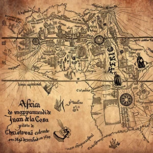
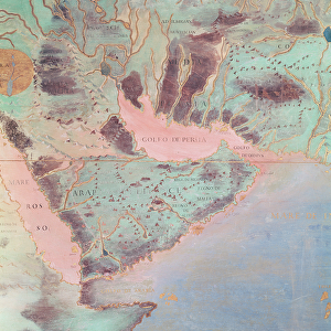
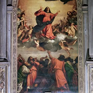
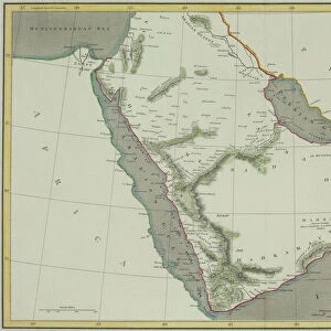
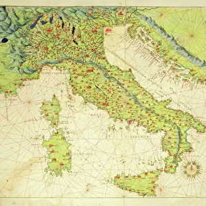
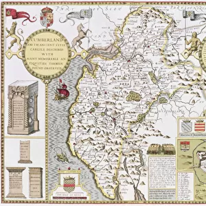
Ethiopia, the Red Sea and Saudi Arabia, from an Atlas of the World in 33 Maps, Venice

![]()
Wall Art and Photo Gifts from Fine Art Finder
Ethiopia, the Red Sea and Saudi Arabia, from an Atlas of the World in 33 Maps, Venice
XOT330947 Ethiopia, the Red Sea and Saudi Arabia, from an Atlas of the World in 33 Maps, Venice, 1st September 1553 (ink on vellum) (detail from 330946) by Agnese, Battista (1514-64); Museo Correr, Venice, Italy; Italian, out of copyright
Media ID 12852656
© www.bridgemanart.com
Cartography East Africa Mapping Monarchs Monarch Rulers
FEATURES IN THESE COLLECTIONS
> Africa
> Ethiopia (Abyssinia)
> Related Images
> Africa
> Ethiopia
> Related Images
> Arts
> Artists
> A
> Battista Agnese
> Asia
> Saudi Arabia
> Maps
> Europe
> Italy
> Veneto
> Venice
> Fine Art Finder
> Artists
> Battista Agnese
> Fine Art Finder
> Maps (celestial & Terrestrial)
> Maps and Charts
> Italy
EDITORS COMMENTS
This print showcases a detailed map titled "Ethiopia, the Red Sea and Saudi Arabia" from an ancient Atlas of the World in 33 Maps. Created by the talented Italian cartographer Battista Agnese in Venice on 1st September 1553, this ink on vellum masterpiece is now housed at Museo Correr in Venice, Italy. The intricate details of this map transport us back to a time when exploration was limited and knowledge of distant lands was scarce. It offers a glimpse into the geographical understanding of East Africa and the Middle East during that era. Highlighted within this stunning artwork are Ethiopia, the Red Sea, and Saudi Arabia. The precision with which Agnese has depicted these regions demonstrates his mastery as a cartographer. The map not only captures their physical features but also provides insight into political boundaries and rulership during that period. As we admire this historical artifact, it serves as a reminder of how far our understanding of geography has evolved over centuries. It sparks curiosity about early explorers who ventured into unknown territories to expand our collective knowledge. Thanks to Fine Art Finder's preservation efforts, we can appreciate and learn from artworks like these today. Let us delve deeper into history through such remarkable pieces that bridge gaps between different eras and cultures while igniting our imagination for further exploration.
MADE IN THE USA
Safe Shipping with 30 Day Money Back Guarantee
FREE PERSONALISATION*
We are proud to offer a range of customisation features including Personalised Captions, Color Filters and Picture Zoom Tools
SECURE PAYMENTS
We happily accept a wide range of payment options so you can pay for the things you need in the way that is most convenient for you
* Options may vary by product and licensing agreement. Zoomed Pictures can be adjusted in the Cart.