Home > Europe > United Kingdom > England > Manchester > Salford
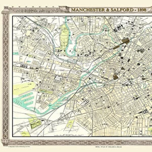
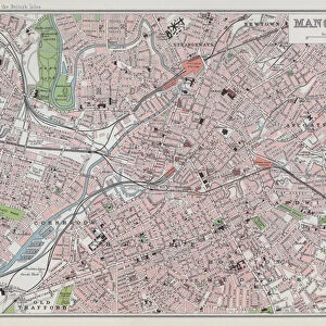
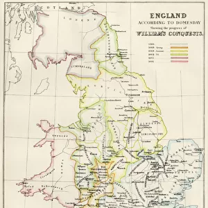
Royal Atlas, c 1900: Manchester and Salford (colour litho)
")
![]()
Wall Art and Photo Gifts from Fine Art Finder
Royal Atlas, c 1900: Manchester and Salford (colour litho)
7198212 Royal Atlas, c 1900: Manchester and Salford (colour litho) by English School, (20th century); Private Collection; (add.info.: Manchester and Salford. Illustration for The Royal Atlas of England and Wales, reduced from the Ordnance Survey, edited by J G Bartholomew [1860-1920] (George Newnes, c 1900).); © Look and Learn
Media ID 24685344
© Look and Learn / Bridgeman Images
City Map City Plan General Map Manchester Royal Atlas Street Plan
FEATURES IN THESE COLLECTIONS
> Europe
> United Kingdom
> England
> Manchester
> Manchester
> Europe
> United Kingdom
> England
> Manchester
> Salford
> Europe
> United Kingdom
> England
> Maps
> Europe
> United Kingdom
> England
> Salford
> Europe
> United Kingdom
> Maps
> Europe
> United Kingdom
> Wales
> Maps
> Europe
> United Kingdom
> Wales
> Posters
> Europe
> United Kingdom
> Wales
> Related Images
> Fine Art Finder
> Artists
> English School
> Maps and Charts
> Early Maps
> Maps and Charts
> Related Images
EDITORS COMMENTS
This vibrant and detailed print captures the essence of Manchester and Salford in the early 20th century. The Royal Atlas, c 1900, showcases a colourful lithograph created by an English School artist. This illustration was originally featured in The Royal Atlas of England and Wales, edited by J G Bartholomew. The map provides a comprehensive view of these bustling cities, reduced from the Ordnance Survey. Every street plan and city plan is meticulously depicted, allowing viewers to explore every nook and cranny of Manchester and Salford during this time period. The rich colours used in this lithograph bring life to the map, highlighting important landmarks such as buildings, parks, rivers, and roads. It offers a glimpse into what life was like for residents at that time. As we delve into this piece of artistry from the early twentieth century, we are transported back to an era when these two cities were rapidly growing industrial powerhouses. The intricate details invite us to imagine the hustle and bustle on those streets filled with horse-drawn carriages and people going about their daily lives. This print is not only a visual feast but also serves as a historical document showcasing how Manchester and Salford appeared over a hundred years ago. It stands as a testament to both artistic skill and cartographic accuracy while providing us with insight into our past.
MADE IN THE USA
Safe Shipping with 30 Day Money Back Guarantee
FREE PERSONALISATION*
We are proud to offer a range of customisation features including Personalised Captions, Color Filters and Picture Zoom Tools
SECURE PAYMENTS
We happily accept a wide range of payment options so you can pay for the things you need in the way that is most convenient for you
* Options may vary by product and licensing agreement. Zoomed Pictures can be adjusted in the Cart.