Home > Europe > United Kingdom > England > Northumberland > Bamburgh
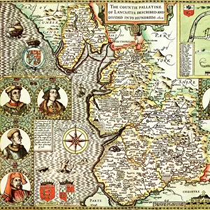
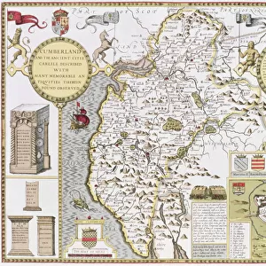
Maps of Holy Island and Farne Island, Northumberland, from The Theatre of the

![]()
Wall Art and Photo Gifts from Fine Art Finder
Maps of Holy Island and Farne Island, Northumberland, from The Theatre of the
XJF448282 Maps of Holy Island and Farne Island, Northumberland, from The Theatre of the Empire of Great Britaine by John Speed, 1676 (engraving) by Speed, John (1552-1629); Private Collection; (add.info.: The North Sea was known as the German Ocean until the early 20th century when hostilities with Germany caused the name to be changed; ); English, out of copyright
Media ID 12883536
© www.bridgemanart.com
Archipelago Bamburgh Castle Cartographic Holy Island North Sea Northumberland Farne Island Staple Island
FEATURES IN THESE COLLECTIONS
> Arts
> Artists
> O
> Oceanic Oceanic
> Arts
> Artists
> S
> John Speed
> Europe
> United Kingdom
> England
> Northumberland
> Bamburgh
> Europe
> United Kingdom
> England
> Northumberland
> Related Images
> Fine Art Finder
> Artists
> John Speed
> Fine Art Finder
> Maps (celestial & Terrestrial)
> Maps and Charts
> Early Maps
> Maps and Charts
> Related Images
EDITORS COMMENTS
This print showcases the intricate and detailed maps of Holy Island and Farne Island, located in Northumberland. Created by the renowned cartographer John Speed in 1676, these engravings are a testament to his exceptional skill and precision. The maps provide a fascinating glimpse into the geography and topography of this coastal region. The archipelago is beautifully depicted, with each island clearly labeled and positioned accurately within the North Sea, which was known as the German Ocean until the early 20th century. Notable landmarks such as Bamburgh Castle stand proudly on these ancient maps, offering a glimpse into their historical significance. The Theatre of the Empire of Great Britaine serves not only as an informative tool but also as a work of art that captures the essence of this remarkable area. As you explore this photo print, your eyes will be drawn to Staple Island, Brownsman, Wamses - all part of this enchanting archipelago. The attention to detail is truly remarkable; every contour line meticulously engraved to showcase its unique features. Whether you have a deep appreciation for cartography or simply admire fine art prints that transport you through time and space, this exquisite piece from Fine Art Finder is sure to captivate your imagination. Step back into history with these magnificent maps that reveal both beauty and knowledge about Holy Island and Farne Island in Northumberland.
MADE IN THE USA
Safe Shipping with 30 Day Money Back Guarantee
FREE PERSONALISATION*
We are proud to offer a range of customisation features including Personalised Captions, Color Filters and Picture Zoom Tools
FREE COLORIZATION SERVICE
You can choose advanced AI Colorization for this picture at no extra charge!
SECURE PAYMENTS
We happily accept a wide range of payment options so you can pay for the things you need in the way that is most convenient for you
* Options may vary by product and licensing agreement. Zoomed Pictures can be adjusted in the Cart.


![A GARLAND FOR MAY DAY, 1913. A Garland for May day [The Many Arguments for Socialism]](/sq/497/garland-may-day-1913-garland-may-day-the-12320695.jpg.webp)