Home > Maps and Charts > Americas
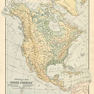
Map North America 1888

![]()
Wall Art and Photo Gifts from Fine Art Storehouse
Map North America 1888
Butlers Elementary Geography by Jacques W. Redway - Philadelphia 1888
Unleash your creativity and transform your space into a visual masterpiece!
THEPALMER
Media ID 20114749
© A 2014 Roberto Adrian Photography
FEATURES IN THESE COLLECTIONS
> Fine Art Storehouse
> Map
> Historical Maps
> Maps and Charts
> Related Images
EDITORS COMMENTS
In this print titled "Map North America 1888" we are transported back in time to the late 19th century, immersing ourselves in a world of exploration and discovery. The map, taken from Jacques W. Redway's renowned book "Butlers Elementary Geography" offers us a glimpse into the geographical knowledge of that era. As our eyes wander across the intricately detailed contours of North America, we can't help but marvel at the artistry and precision with which it was crafted. Every river, mountain range, and city is meticulously labeled, inviting us to embark on an imaginary journey through this vast continent. The faded hues and delicate lines evoke a sense of nostalgia, reminding us of a bygone era when maps were cherished objects that sparked curiosity and fueled dreams of adventure. It serves as a testament to human ingenuity and our unrelenting desire to understand the world around us. This print captures not only historical significance but also artistic beauty. Its presence on any wall would undoubtedly add sophistication and intrigue to any space while serving as a reminder of how far we have come in our understanding of geography. "The Map North America 1888" by THEPALMER takes us on an enchanting voyage through time, allowing us to appreciate both the past accomplishments and future possibilities that lie within these ancient cartographic lines.
MADE IN THE USA
Safe Shipping with 30 Day Money Back Guarantee
FREE PERSONALISATION*
We are proud to offer a range of customisation features including Personalised Captions, Color Filters and Picture Zoom Tools
SECURE PAYMENTS
We happily accept a wide range of payment options so you can pay for the things you need in the way that is most convenient for you
* Options may vary by product and licensing agreement. Zoomed Pictures can be adjusted in the Cart.