Home > Arts > Street art graffiti > Digital art > Vector illustrations
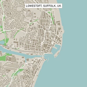
Roswell New Mexico US City Street Map

![]()
Wall Art and Photo Gifts from Fine Art Storehouse
Roswell New Mexico US City Street Map
Vector Illustration of a City Street Map of Roswell, New Mexico, USA. Scale 1:60, 000.
All source data is in the public domain.
U.S. Geological Survey, US Topo
Used Layers:
USGS The National Map: National Hydrography Dataset (NHD)
USGS The National Map: National Transportation Dataset (NTD)
Unleash your creativity and transform your space into a visual masterpiece!
Frank Ramspott
Media ID 15215834
© Frank Ramspott, all rights reserved
Aerial View City Map Computer Graphic Directly Above Downtown District Gray New Mexico Road Map Text Digitally Generated Image Green Color Roswell White Color
FEATURES IN THESE COLLECTIONS
> Aerial Photography
> Related Images
> Animals
> Insects
> Hemiptera
> Green Scale
> Arts
> Contemporary art
> Digital artwork
> Street art
> Arts
> Landscape paintings
> Waterfall and river artworks
> River artworks
> Arts
> Portraits
> Pop art gallery
> Street art portraits
> Arts
> Street art graffiti
> Digital art
> Digital paintings
> Arts
> Street art graffiti
> Digital art
> Vector illustrations
> Fine Art Storehouse
> Map
> Street Maps
> Fine Art Storehouse
> Map
> USA Maps
> Maps and Charts
> Geological Map
> Maps and Charts
> Related Images
> North America
> Mexico
> Lakes
> Related Images
EDITORS COMMENTS
This print showcases a meticulously crafted vector illustration of the city street map of Roswell, New Mexico, USA. With a scale of 1:60,000, every intricate detail is brought to life in this stunning artwork. The source data used for this masterpiece is in the public domain and comes from reputable sources such as the U. S. Geological Survey and US Topo. The various layers utilized include USGS The National Map's National Hydrography Dataset (NHD) and National Transportation Dataset (NTD), ensuring accuracy and authenticity in depicting the city's hydrography and transportation systems. In this digitally generated image, we are presented with an aerial view directly above Roswell's downtown district. The vibrant colors of gray, blue, white, and green beautifully highlight the streets, roads, lake, river, and other geographical features that make up this charming town. With no people present in the scene but accompanied by clear text labels indicating important landmarks and areas within Roswell's city limits; it serves as both an informative tool for navigation purposes as well as a visually appealing piece of art. Created by talented artist Frank Ramspott exclusively for Fine Art Storehouse; this unique print offers a fusion of cartography and design that will captivate any viewer with its attention to detail and artistic flair.
MADE IN THE USA
Safe Shipping with 30 Day Money Back Guarantee
FREE PERSONALISATION*
We are proud to offer a range of customisation features including Personalised Captions, Color Filters and Picture Zoom Tools
SECURE PAYMENTS
We happily accept a wide range of payment options so you can pay for the things you need in the way that is most convenient for you
* Options may vary by product and licensing agreement. Zoomed Pictures can be adjusted in the Cart.