Home > Europe > United Kingdom > England > Hertfordshire > Green Street
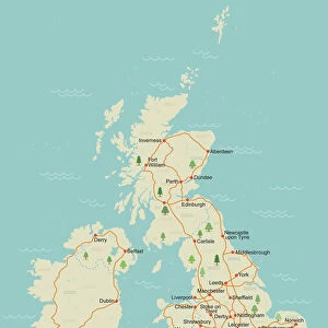
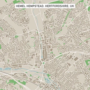
Stevenage Hertfordshire UK City Street Map

![]()
Wall Art and Photo Gifts from Fine Art Storehouse
Stevenage Hertfordshire UK City Street Map
Vector Illustration of a City Street Map of Stevenage, Hertfordshire, UK. Included files are EPS (v10) and Hi-Res JPG.
Data courtesy from Ordnance Survey: VectorMap District
https:/ordnancesurvey.co.uk/business-and-government/products/vectormap-district.html
OS OpenData is free to use under the Open Government Licence (OGL).
Contains OS data eCrown copyright and database right 2017.
http:/nationalarchives.gov.uk/doc/open-government-licence/version/3/
Unleash your creativity and transform your space into a visual masterpiece!
Frank Ramspott
Media ID 15055251
© Frank Ramspott, all rights reserved
Aerial View Computer Graphic Directly Above Gray Green Hertfordshire Road Map Street Map Text Digitally Generated Image Stevenage
FEATURES IN THESE COLLECTIONS
> Aerial Photography
> Related Images
> Arts
> Contemporary art
> Digital artwork
> Street art
> Arts
> Portraits
> Pop art gallery
> Street art portraits
> Arts
> Street art graffiti
> Digital art
> Digital paintings
> Arts
> Street art graffiti
> Digital art
> Vector illustrations
> Europe
> United Kingdom
> England
> Hertfordshire
> Green Street
> Europe
> United Kingdom
> England
> Hertfordshire
> Related Images
> Europe
> United Kingdom
> England
> Hertfordshire
> Stevenage
> Europe
> United Kingdom
> Maps
> Fine Art Storehouse
> Map
> Street Maps
> Maps and Charts
> Related Images
EDITORS COMMENTS
This stunning print showcases a detailed and intricate city street map of Stevenage, Hertfordshire, UK. Created as a vector illustration, the map captures every building, road, and street in this vibrant city. The inclusion of EPS (v10) and Hi-Res JPG files ensures that this artwork can be enjoyed in various formats. The accuracy and precision of this map are made possible by the data courtesy from Ordnance Survey: VectorMap District. This reliable source provides comprehensive information about the city's layout and infrastructure. It is worth noting that OS OpenData allows free usage under the Open Government Licence (OGL), emphasizing its accessibility to all. With no people present in the image, the focus remains solely on the captivating cartography design. Digitally generated with expert skill by Frank Ramspott, this visually striking piece offers an aerial view directly above Stevenage. The color scheme features shades of gray, green, blue, and white which beautifully complement each other. Ideal for those fascinated by geography or anyone seeking a unique decorative piece for their home or office space, this print effortlessly combines artistry with functionality. Explore every corner of Stevenage through this remarkable creation that encapsulates both physical geography and computer graphics seamlessly.
MADE IN THE USA
Safe Shipping with 30 Day Money Back Guarantee
FREE PERSONALISATION*
We are proud to offer a range of customisation features including Personalised Captions, Color Filters and Picture Zoom Tools
SECURE PAYMENTS
We happily accept a wide range of payment options so you can pay for the things you need in the way that is most convenient for you
* Options may vary by product and licensing agreement. Zoomed Pictures can be adjusted in the Cart.