Home > Aerial Photography > Related Images
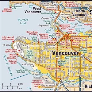
Vancouver Washington US City Street Map

![]()
Wall Art and Photo Gifts from Fine Art Storehouse
Vancouver Washington US City Street Map
Vector Illustration of a City Street Map of Vancouver, Washington, USA. Scale 1:60, 000.
All source data is in the public domain.
U.S. Geological Survey, US Topo
Used Layers:
USGS The National Map: National Hydrography Dataset (NHD)
USGS The National Map: National Transportation Dataset (NTD)
Unleash your creativity and transform your space into a visual masterpiece!
Frank Ramspott
Media ID 15054999
© Frank Ramspott, all rights reserved
Aerial View City Map Columbia River Computer Graphic Directly Above Downtown District Gray Road Map Text Vancouver Washington State Digitally Generated Image Green Color White Color
FEATURES IN THESE COLLECTIONS
> Aerial Photography
> Related Images
> Animals
> Insects
> Hemiptera
> Green Scale
> Arts
> Contemporary art
> Digital artwork
> Street art
> Arts
> Landscape paintings
> Waterfall and river artworks
> River artworks
> Arts
> Portraits
> Pop art gallery
> Street art portraits
> Arts
> Street art graffiti
> Digital art
> Digital paintings
> Arts
> Street art graffiti
> Digital art
> Vector illustrations
> Fine Art Storehouse
> Map
> Street Maps
> Fine Art Storehouse
> Map
> USA Maps
> Maps and Charts
> Geological Map
> Maps and Charts
> Related Images
> North America
> United States of America
> Lakes
> Related Images
EDITORS COMMENTS
This print showcases a meticulously detailed city street map of Vancouver, Washington, USA. With a scale of 1:60,000, every nook and cranny of this charming city is beautifully illustrated in vector format. The artist, Frank Ramspott, has skillfully utilized various layers from the USGS The National Map to create this stunning piece. The map encompasses all the essential elements that define Vancouver's landscape - from the tranquil Vancouver Lake to the majestic Columbia River that gracefully winds its way through the city. The downtown district stands out with its vibrant energy and bustling streets. Each road and intersection is intricately depicted, making it easy for viewers to navigate their way around town. Rendered in an array of colors including shades of gray, blue, white, and green; this digitally generated image offers a unique perspective on Vancouver's physical geography. From high above in an aerial view perspective directly above the city streetscape; one can appreciate both the artistry behind this design as well as gain insights into the layout and structure of this urban environment. With no people present in the image itself but accompanied by text providing additional context about its creation process and source data being sourced from public domain repositories such as U. S Geological Survey (USGS), this print serves as not only a visually appealing decorative piece but also as an informative cartographic representation of Vancouver's urban fabric.
MADE IN THE USA
Safe Shipping with 30 Day Money Back Guarantee
FREE PERSONALISATION*
We are proud to offer a range of customisation features including Personalised Captions, Color Filters and Picture Zoom Tools
SECURE PAYMENTS
We happily accept a wide range of payment options so you can pay for the things you need in the way that is most convenient for you
* Options may vary by product and licensing agreement. Zoomed Pictures can be adjusted in the Cart.