Home > Europe > Netherlands > Dance
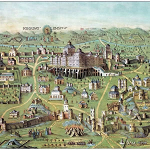
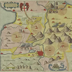
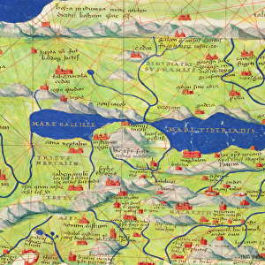
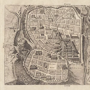
The Jerusalem Map (From: Civitates Orbis Terrarum), 1572
, 1572")
![]()
Wall Art and Photo Gifts from Heritage Images
The Jerusalem Map (From: Civitates Orbis Terrarum), 1572
The Jerusalem Map (From: Civitates Orbis Terrarum), 1572. Private Collection
Heritage Images features heritage image collections
Media ID 15050465
© / Heritage-Images
Biblical Places Braun Cartography Georg 1541 1622 Israel Jerusalem The Netherlands Copper Engraving
FEATURES IN THESE COLLECTIONS
> Europe
> Netherlands
> Dance
> Europe
> Netherlands
> Maps
> Europe
> Netherlands
> Music
> Popular Themes
> Dance
EDITORS COMMENTS
This print showcases "The Jerusalem Map (From: Civitates Orbis Terrarum), 1572" a stunning piece of cartography created by Georg Braun in the late 16th century. The intricate details and exquisite craftsmanship of this copper engraving are truly remarkable. Depicting biblical places with precision, this map offers a glimpse into the rich history and cultural significance of Jerusalem. Its watercolor touches add depth and vibrancy to each landmark, transporting viewers back in time to an era steeped in religious fervor. Housed within a private collection, this rare artifact serves as a testament to the enduring fascination with ancient maps and their ability to transport us through space and time. It is a visual feast for art enthusiasts, historians, and anyone captivated by the beauty of fine graphic arts. Beyond its historical value, this image evokes emotions that extend beyond mere aesthetics. The dance between music and art becomes palpable as one explores every corner of this masterpiece. It invites us to immerse ourselves in the melodies that once echoed through these streets centuries ago. "The Jerusalem Map" not only provides geographical insights but also acts as a portal connecting past civilizations with our present-day understanding of Israel's capital city. As we gaze upon it, we cannot help but marvel at how much has changed yet remains unchanged over centuries—a true testament to humanity's resilience throughout history.
MADE IN THE USA
Safe Shipping with 30 Day Money Back Guarantee
FREE PERSONALISATION*
We are proud to offer a range of customisation features including Personalised Captions, Color Filters and Picture Zoom Tools
SECURE PAYMENTS
We happily accept a wide range of payment options so you can pay for the things you need in the way that is most convenient for you
* Options may vary by product and licensing agreement. Zoomed Pictures can be adjusted in the Cart.