Home > Europe > United Kingdom > Scotland > Edinburgh > Edinburgh
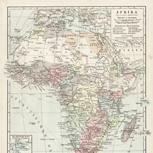
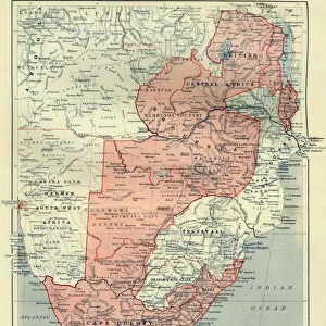
Map of Africa, 1902. Creator: Unknown

![]()
Wall Art and Photo Gifts from Heritage Images
Map of Africa, 1902. Creator: Unknown
Map of Africa, 1902. Showing colonial possessions including French West Africa and German South West Africa, with insets of Table Bay in South Africa, and British and German East Africa. From The Century Atlas of the World. [John Walker & Co, Ltd. London, 1902]
Heritage Images features heritage image collections
Media ID 15512304
© The Print Collector / Heritage-Images
Desert Edinburgh Geographical Institute Imperialism Sahara Sahara Desert
FEATURES IN THESE COLLECTIONS
> Africa
> South Africa
> Maps
> Europe
> United Kingdom
> England
> London
> Related Images
> Europe
> United Kingdom
> Scotland
> Edinburgh
> Edinburgh
> Europe
> United Kingdom
> Scotland
> Lothian
> Edinburgh
EDITORS COMMENTS
This print showcases a historical treasure - the Map of Africa from 1902. Created by an unknown artist, this map provides a glimpse into the colonial possessions and imperial ambitions of various European powers during that time. The intricate details highlight the vastness and diversity of the African continent. The map prominently displays French West Africa and German South West Africa, indicating their respective territories in vibrant colors. Insets featuring Table Bay in South Africa, as well as British and German East Africa, offer additional geographical insights. Published in The Century Atlas of the World by John Walker & Co. , Ltd. in London, this artifact serves as a valuable resource for understanding the political landscape of early 20th-century Africa. It sheds light on Britain's presence along its coastlines, France's extensive holdings across different regions, and Germany's aspirations to establish colonies within the continent. The Sahara Desert stands out as a prominent geographical feature on this map - an expanse that has shaped African history for centuries. With impeccable attention to detail provided by Edinburgh Geographical Institute, every country is clearly demarcated with precision. As we admire this remarkable print from The Print Collector collection without commercial use intentions, it reminds us of both the legacy of imperialism and colonialism that impacted African nations profoundly but also serves as a testament to our shared human history.
MADE IN THE USA
Safe Shipping with 30 Day Money Back Guarantee
FREE PERSONALISATION*
We are proud to offer a range of customisation features including Personalised Captions, Color Filters and Picture Zoom Tools
SECURE PAYMENTS
We happily accept a wide range of payment options so you can pay for the things you need in the way that is most convenient for you
* Options may vary by product and licensing agreement. Zoomed Pictures can be adjusted in the Cart.