Home > Europe > United Kingdom > Scotland > Edinburgh > Edinburgh
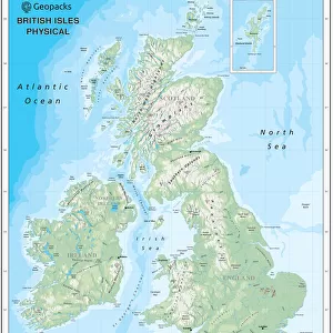
Physical Map of the British Isles, 1902. Creator: Unknown

![]()
Wall Art and Photo Gifts from Heritage Images
Physical Map of the British Isles, 1902. Creator: Unknown
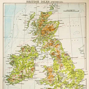
Physical Map of the British Isles, 1902. Highest points shown in red. From The Century Atlas of the World. [John Walker & Co, Ltd. London, 1902]
Heritage Images features heritage image collections
Media ID 15512546
© The Print Collector / Heritage-Images
British Isles Coastline Edinburgh Geographical Institute Height Physical
FEATURES IN THESE COLLECTIONS
> Europe
> United Kingdom
> Scotland
> Edinburgh
> Edinburgh
> Europe
> United Kingdom
> Scotland
> Lothian
> Edinburgh
> Maps and Charts
> Related Images
> Maps and Charts
> World
EDITORS COMMENTS
This print showcases a Physical Map of the British Isles from 1902, revealing the intricate geographical features and majestic mountains that shape this historic region. The creator of this masterpiece remains unknown, adding an air of mystery to its allure. The map is brought to life with vibrant colors, highlighting various elevations across the landscape. The highest points are depicted in striking red hues, drawing our attention to these magnificent peaks that dot the British Isles. It is fascinating to observe how geography played a crucial role in shaping the history and culture of this land. Printed as part of The Century Atlas of the World by John Walker & Co. , Ltd. , London in 1902, this piece offers a glimpse into cartographic artistry at the turn of the 20th century. Each contour line meticulously represents changes in height and terrain throughout Britain's coastline. As we explore every inch of this map, we can't help but appreciate Edinburgh Geographical Institute's dedication to accuracy and detail. This physical map serves not only as a visual delight but also as an educational tool for understanding Britain's diverse landscapes. Preserved by The Print Collector, it stands as a testament to their commitment towards conserving historical artifacts for future generations' appreciation. While its original purpose may have been utilitarian, today it holds immense value as both an artistic creation and a window into our past.
MADE IN THE USA
Safe Shipping with 30 Day Money Back Guarantee
FREE PERSONALISATION*
We are proud to offer a range of customisation features including Personalised Captions, Color Filters and Picture Zoom Tools
SECURE PAYMENTS
We happily accept a wide range of payment options so you can pay for the things you need in the way that is most convenient for you
* Options may vary by product and licensing agreement. Zoomed Pictures can be adjusted in the Cart.