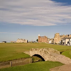
Home > Europe > United Kingdom > Scotland > Fife > St Andrews
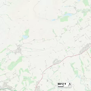
Hyndburn BB6 8 Map

![]()
Wall Art and Photo Gifts from Map Marketing
Hyndburn BB6 8 Map
Postcode Sector Map of Hyndburn BB6 8
Media ID 19965590
Brookside Chapel Lane Cherry Drive Damson Close Dickens Court Eden Gardens Fields End Gleneagles Drive Hawthorn Close Hillcrest Road Hyndburn Kenyon Lane Kirkdale Road Larkhill Masefield Close Moorland Road Northcote Road Portland Road Springdale Road St Andrews Road St Marys Drive The Dales The Drive The Woodlands Tudor Close Whalley Road York York Lane
FEATURES IN THESE COLLECTIONS
> Europe
> United Kingdom
> Scotland
> Fife
> St Andrews
> Map Marketing
> Postcode Sector Maps
> BB - Blackburn
> Maps and Charts
> Related Images
MADE IN THE USA
Safe Shipping with 30 Day Money Back Guarantee
FREE PERSONALISATION*
We are proud to offer a range of customisation features including Personalised Captions, Color Filters and Picture Zoom Tools
SECURE PAYMENTS
We happily accept a wide range of payment options so you can pay for the things you need in the way that is most convenient for you
* Options may vary by product and licensing agreement. Zoomed Pictures can be adjusted in the Cart.