Home > Europe > United Kingdom > Wales > Powys > Montgomery
Bournemouth BH11 8 Map

![]()
Wall Art and Photo Gifts from Map Marketing
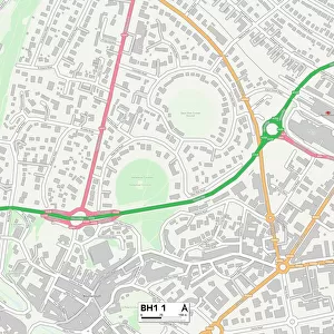
Bournemouth BH11 8 Map
Postcode Sector Map of Bournemouth BH11 8
Media ID 19965502
Andrews Close Bournemouth Coleman Road Cunningham Close Dominion Road Edward Road Elliott Road Evans Close Francis Avenue Hall Road Leyland Road Lydford Road Montgomery Avenue Moore Avenue Moorside Close Moorside Road Mount Road Nutley Close Paget Road Rochester Road Saffron Way St Georges Drive St Marks Road Tedder Close Tedder Road Verney Close Verney Road Wavell Road
FEATURES IN THESE COLLECTIONS
> Arts
> Artists
> P
> Francis Place
> Europe
> United Kingdom
> England
> Maps
> Europe
> United Kingdom
> Scotland
> Fife
> St Andrews
> Europe
> United Kingdom
> Wales
> Powys
> Montgomery
> Map Marketing
> Postcode Sector Maps
> BH - Bournemouth
> Maps and Charts
> Related Images
MADE IN THE USA
Safe Shipping with 30 Day Money Back Guarantee
FREE PERSONALISATION*
We are proud to offer a range of customisation features including Personalised Captions, Color Filters and Picture Zoom Tools
SECURE PAYMENTS
We happily accept a wide range of payment options so you can pay for the things you need in the way that is most convenient for you
* Options may vary by product and licensing agreement. Zoomed Pictures can be adjusted in the Cart.