Home > Europe > United Kingdom > Wales > Pembrokeshire > Pembroke
Bournemouth BH4 8 Map

![]()
Wall Art and Photo Gifts from Map Marketing
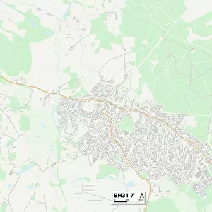
Bournemouth BH4 8 Map
Postcode Sector Map of Bournemouth BH4 8
Media ID 19966064
Beaulieu Road Bournemouth Clarendon Road Crosby Road Grosvenor Road Herbert Road Marlborough Road Milner Road Mountbatten Road Pembroke Road Rosemount Road Studland Road Warren Road Westerham Road Western Road Westbourne
FEATURES IN THESE COLLECTIONS
> Animals
> Mammals
> Muridae
> Western Mouse
> Europe
> United Kingdom
> Wales
> Pembrokeshire
> Pembroke
> Map Marketing
> Postcode Sector Maps
> BH - Bournemouth
> Maps and Charts
> Related Images
MADE IN THE USA
Safe Shipping with 30 Day Money Back Guarantee
FREE PERSONALISATION*
We are proud to offer a range of customisation features including Personalised Captions, Color Filters and Picture Zoom Tools
SECURE PAYMENTS
We happily accept a wide range of payment options so you can pay for the things you need in the way that is most convenient for you
* Options may vary by product and licensing agreement. Zoomed Pictures can be adjusted in the Cart.