Home > Europe > United Kingdom > Wales > Ceredigion > New Quay
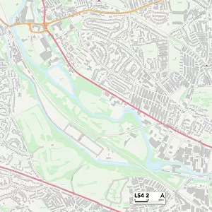
Leeds LS13 1 Map

![]()
Wall Art and Photo Gifts from Map Marketing
Leeds LS13 1 Map
Postcode Sector Map of Leeds LS13 1
Media ID 19974910
Bridge Road Bridge View Brookfield Avenue Canal Road Chapel Street Club Lane Cowley Road Fernbank Fernbank Close Greenwood Close Hardwick Court Hawthorn Drive Hawthorn Grove Horton Close Intake Lane Kirkham Street Langley Avenue Langley Close Langley Crescent Langley Place Langley Road Leeds Longfield Drive Mary Street Moorland View Moorside Oaklands Avenue Oaklands Grove Oaklands Road Orchard Mews Rochester Gardens Rock Lane Shirley Drive St Andrews Close Summerfield Avenue Summerfield Drive Summerfield Road The Rowans Town Street Valley Rise Valley Road Waterside Court Wesley Street Wesley Terrace Westminster Close Westminster Drive Wheatfield Close Wycliffe Road Intake Rodley
FEATURES IN THESE COLLECTIONS
> Arts
> Portraits
> Pop art gallery
> Street art portraits
> Asia
> Georgia
> Related Images
> Europe
> United Kingdom
> Scotland
> Fife
> St Andrews
> Europe
> United Kingdom
> Wales
> Ceredigion
> New Quay
> Map Marketing
> Postcode Sector Maps
> LS - Leeds
> Maps and Charts
> Related Images
MADE IN THE USA
Safe Shipping with 30 Day Money Back Guarantee
FREE PERSONALISATION*
We are proud to offer a range of customisation features including Personalised Captions, Color Filters and Picture Zoom Tools
SECURE PAYMENTS
We happily accept a wide range of payment options so you can pay for the things you need in the way that is most convenient for you
* Options may vary by product and licensing agreement. Zoomed Pictures can be adjusted in the Cart.