Home > Europe > United Kingdom > Scotland > Dumfries and Galloway > Thornhill
High Peak S33 6 Map

![]()
Wall Art and Photo Gifts from Map Marketing
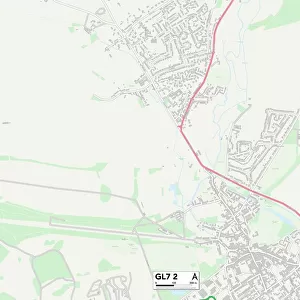
High Peak S33 6 Map
Postcode Sector Map of High Peak S33 6
Media ID 19978908
Aston Aston Lane Bowden Lane Castleton Road Eccles Close Edale Road High Peak Hope Road Market Close Marsh Avenue Parsons Lane School Lane Sherwood Avenue Station Road The Crescent Hope
FEATURES IN THESE COLLECTIONS
> Europe
> United Kingdom
> Scotland
> Dumfries and Galloway
> Thornhill
> Map Marketing
> Postcode Sector Maps
> S - Sheffield
MADE IN THE USA
Safe Shipping with 30 Day Money Back Guarantee
FREE PERSONALISATION*
We are proud to offer a range of customisation features including Personalised Captions, Color Filters and Picture Zoom Tools
SECURE PAYMENTS
We happily accept a wide range of payment options so you can pay for the things you need in the way that is most convenient for you
* Options may vary by product and licensing agreement. Zoomed Pictures can be adjusted in the Cart.