Home > Europe > United Kingdom > Wales > Powys > Newtown
Eastleigh SO31 9 Map

![]()
Wall Art and Photo Gifts from Map Marketing
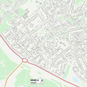
Eastleigh SO31 9 Map
Postcode Sector Map of Eastleigh SO31 9
Media ID 19982158
Beechwood Close Brook Avenue Church Road Coleridge Close Eastleigh Endeavour Close Green Lane Hamble Close Havelock Road Hook Hook Lane Knights Close Mackenzie Close Mariners Way New Road Newtown Newtown Road Oakwood Close Osborne Road Queens Road Romford Road Saxon Close Shore Road Solent Drive Spenser Close Spruce Close Thornton Avenue
FEATURES IN THESE COLLECTIONS
> Animals
> Farm
> Cattle
> Related Images
> Europe
> United Kingdom
> Wales
> Powys
> Newtown
> Map Marketing
> Postcode Sector Maps
> SO - Southampton
> Maps and Charts
> Related Images
MADE IN THE USA
Safe Shipping with 30 Day Money Back Guarantee
FREE PERSONALISATION*
We are proud to offer a range of customisation features including Personalised Captions, Color Filters and Picture Zoom Tools
SECURE PAYMENTS
We happily accept a wide range of payment options so you can pay for the things you need in the way that is most convenient for you
* Options may vary by product and licensing agreement. Zoomed Pictures can be adjusted in the Cart.