Home > Europe > United Kingdom > England > London > Boroughs > Bromley
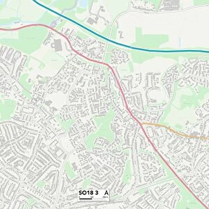
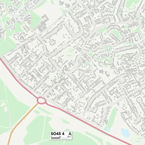
Southampton SO18 2 Map

![]()
Wall Art and Photo Gifts from Map Marketing
Southampton SO18 2 Map
Postcode Sector Map of Southampton SO18 2
Media ID 19981748
Bank Side Barton Crescent Broadwater Road Bromley Road Brookside Way Chester Road Cleveland Road Copse Road Cornwall Close Cornwall Crescent Cornwall Road Dell Road Edgehill Road Exeter Close Exeter Road Friars Way Grange Close Halstead Road Hazelwood Road Howard Close Longmead Road Lytham Road Mead Crescent Meadowside Close Middleton Close Monks Way Northfield Road Norwich Road Old Farm Drive Oliver Road River Walk Roundhill Close Southampton Vale Drive Wakefield Road Walnut Avenue Wycliffe Road Swaythling
FEATURES IN THESE COLLECTIONS
> Arts
> Artists
> D
> Alfred
> Related Images
> Arts
> Artists
> H
> George Howard
> Arts
> Artists
> H
> Robert Hills
> Arts
> Landscape paintings
> Forest and woodland scenes
> Forest artwork
> Arts
> Landscape paintings
> Waterfall and river artworks
> River artworks
> Europe
> United Kingdom
> England
> Cleveland
> Europe
> United Kingdom
> England
> Cornwall
> Related Images
> Europe
> United Kingdom
> England
> Cornwall
> Rose
> Europe
> United Kingdom
> England
> London
> Boroughs
> Bromley
> Map Marketing
> Postcode Sector Maps
> SO - Southampton
> Maps and Charts
> Related Images
MADE IN THE USA
Safe Shipping with 30 Day Money Back Guarantee
FREE PERSONALISATION*
We are proud to offer a range of customisation features including Personalised Captions, Color Filters and Picture Zoom Tools
SECURE PAYMENTS
We happily accept a wide range of payment options so you can pay for the things you need in the way that is most convenient for you
* Options may vary by product and licensing agreement. Zoomed Pictures can be adjusted in the Cart.