Home > Europe > United Kingdom > Northern Ireland > County Armagh > Craigavon
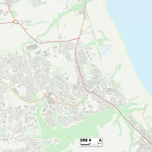
Sunderland SR5 3 Map

![]()
Wall Art and Photo Gifts from Map Marketing
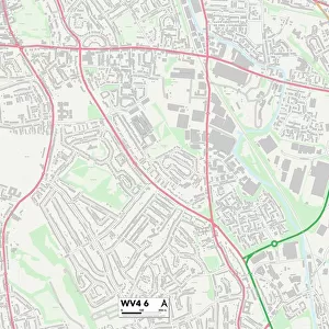
Sunderland SR5 3 Map
Postcode Sector Map of Sunderland SR5 3
Media ID 19981466
Alder Street Almond Drive Ashwood Grove Caithness Road Campbell Road Canterbury Road Cardigan Road Cartwright Road Castle View Chatham Road Cheadle Road Chelmsford Road Cheltenham Road Clacton Road Clovelly Road Coleridge Road Conway Road Cotswold Road Cranleigh Road Dene Park Dene Road East View Elizabeth Street Gordon Avenue Grange Road Hepworth Road Laburnum Grove Lavender Grove North View Ringway Riverdale Riverside Road Rydal Mount Shannon Close Sherbourne Road St Catherines Court St Margarets Avenue Stanley Street Sunderland Swan Court The Briars The Grove Vicarage Court Washington Road Welwyn Close West View Castletown Walworth Road
FEATURES IN THESE COLLECTIONS
> Arts
> Artists
> P
> Gordon Parks
> Arts
> Portraits
> Pop art gallery
> Street art portraits
> Europe
> United Kingdom
> Northern Ireland
> County Armagh
> Craigavon
> Europe
> United Kingdom
> Scotland
> Caithness
> Europe
> United Kingdom
> Scotland
> Perth and Kinross
> Crieff
> Europe
> United Kingdom
> Scotland
> Western Isles
> Kirkwall
> Europe
> United Kingdom
> Wales
> Ceredigion
> Cardigan
> Europe
> United Kingdom
> Wales
> South Glamorgan
> Cardiff
> Map Marketing
> Postcode Sector Maps
> SR - Sunderland
> Maps and Charts
> Related Images
> Posters
> Movie Posters
> Laburnum Grove
MADE IN THE USA
Safe Shipping with 30 Day Money Back Guarantee
FREE PERSONALISATION*
We are proud to offer a range of customisation features including Personalised Captions, Color Filters and Picture Zoom Tools
SECURE PAYMENTS
We happily accept a wide range of payment options so you can pay for the things you need in the way that is most convenient for you
* Options may vary by product and licensing agreement. Zoomed Pictures can be adjusted in the Cart.