Home > Europe > France > Canton > Landes
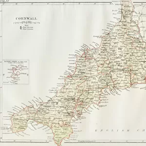
Cornwall PL17 8 Map

![]()
Wall Art and Photo Gifts from Map Marketing
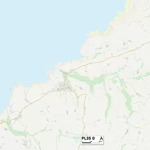
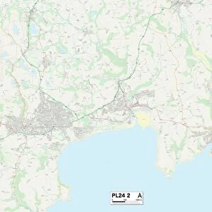
Cornwall PL17 8 Map
Postcode Sector Map of Cornwall PL17 8
Media ID 19978282
Anvil Court Ashton Chestnut Close Cornwall Dingle Close Dukes Drive Florence Road Glebelands Harris Close Kingston Kingston Road Launceston Road Laurel Lane Longacre Newton Parsons Green Pound Lane School Lane Station Road Stoke Road Wesley Close Wilkinson Close Windsor Lane Old Mill
FEATURES IN THESE COLLECTIONS
> Europe
> France
> Canton
> Landes
> Europe
> United Kingdom
> England
> Cornwall
> Ashton
> Europe
> United Kingdom
> England
> Cornwall
> Callington
> Europe
> United Kingdom
> England
> Cornwall
> Coombe
> Europe
> United Kingdom
> England
> Cornwall
> Holmbush
> Europe
> United Kingdom
> England
> Cornwall
> Launceston
> Europe
> United Kingdom
> England
> Cornwall
> Redmoor
> Europe
> United Kingdom
> England
> Cornwall
> Related Images
> Europe
> United Kingdom
> England
> Cornwall
> Row
> Europe
> United Kingdom
> England
> Cornwall
> Shop
> Map Marketing
> Postcode Sector Maps
> PL - Plymouth
> Map Marketing
> UK Maps
MADE IN THE USA
Safe Shipping with 30 Day Money Back Guarantee
FREE PERSONALISATION*
We are proud to offer a range of customisation features including Personalised Captions, Color Filters and Picture Zoom Tools
SECURE PAYMENTS
We happily accept a wide range of payment options so you can pay for the things you need in the way that is most convenient for you
* Options may vary by product and licensing agreement. Zoomed Pictures can be adjusted in the Cart.