Home > Arts > Artists > S > John Speed
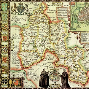
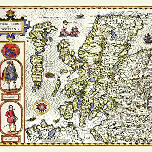
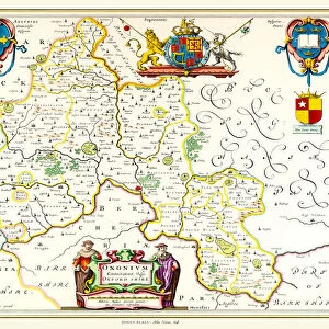
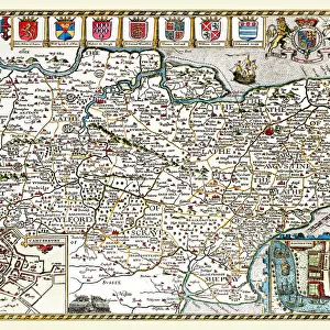
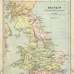
Old County Map of Oxfordshire 1611 by John Speed

![]()
Wall Art and Photo Gifts from MapSeeker
Old County Map of Oxfordshire 1611 by John Speed
A facimile of John Speeds historical map of Oxfordshire originally published for the " Theatre of the Empire of Great Britain", an atlas to accompany " a history of Great Britain"
Welcome to the Mapseeker Image library and enter an historic gateway to one of the largest on-line collections of Historic Maps, Nostalgic Views, Vista's and Panorama's from a World gone by.
Media ID 20347566
© Mapseeker Publishing Ltd
County Map County Map Of England English County Map Historic Map John Speed Map Old County Map Old English County Map Speed Map Speede Map Oxfordshire
FEATURES IN THESE COLLECTIONS
> Arts
> Artists
> S
> John Speed
> Europe
> United Kingdom
> England
> Maps
> Europe
> United Kingdom
> England
> Oxfordshire
> Related Images
> Maps and Charts
> British Empire Maps
> Maps and Charts
> Early Maps
> Maps and Charts
> Related Images
> MapSeeker
> Maps from the British Isles
> England and Counties PORTFOLIO
EDITORS COMMENTS
This print showcases an exquisite piece of history - the "Old County Map of Oxfordshire 1611" by John Speed. A faithful reproduction of Speed's original map, which was first published for his renowned work "The Theatre of the Empire of Great Britain" this facsimile offers a glimpse into the past and provides a valuable resource for understanding the county's rich heritage. John Speed, a prominent cartographer and historian, meticulously crafted this map to accompany his comprehensive account titled "A History of Great Britain". With intricate details and artistic flair, he captured the essence of Oxfordshire in 1611. This old English county map is not just a geographical representation but also an invaluable historical artifact that transports us back to a time when England was undergoing significant social and political changes. As we explore this historic Oxfordshire map, we are transported through its towns, villages, rivers, and landscapes. The attention to detail is remarkable as every road and settlement is carefully labeled. It serves as both an educational tool for scholars studying British history and a beautiful decorative piece that adds character to any space. Whether you have personal ties to Oxfordshire or simply appreciate historical maps, this John Speed masterpiece will undoubtedly captivate your imagination. Let it transport you back in time as you marvel at the intricacies woven into each stroke on this fascinating piece of cartographic artistry.
MADE IN THE USA
Safe Shipping with 30 Day Money Back Guarantee
FREE PERSONALISATION*
We are proud to offer a range of customisation features including Personalised Captions, Color Filters and Picture Zoom Tools
SECURE PAYMENTS
We happily accept a wide range of payment options so you can pay for the things you need in the way that is most convenient for you
* Options may vary by product and licensing agreement. Zoomed Pictures can be adjusted in the Cart.