Home > Europe > United Kingdom > Scotland > Renfrewshire
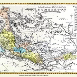
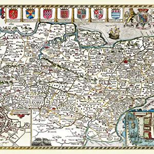
Old County Map of Renfrew Scotland 1847 by A&C Black

![]()
Wall Art and Photo Gifts from MapSeeker
Old County Map of Renfrew Scotland 1847 by A&C Black
A finely detailed facimile remastered in full colour from an antique original map of Renfrewshire featured in A&C Blacks Atlas of 1847. Each Parish is numbered using an index table, colour rendition beautifully differentiating all of the Parishes. As well as principal roads, towns, villages and hamlets, these county maps of Scotland feature key battle sites marked with two crossed swords and the date of the battle
Welcome to the Mapseeker Image library and enter an historic gateway to one of the largest on-line collections of Historic Maps, Nostalgic Views, Vista's and Panorama's from a World gone by.
Media ID 20347578
© Mapseeker Publishing Ltd
A And C Black A And C Black Atlas A And C Black Map County Map County Map Of Scotland Historic Map Old County Map Old Scottish County Map Scottish County Map Renfrew Renfrewshire
FEATURES IN THESE COLLECTIONS
> Arts
> Photorealistic artworks
> Detailed art pieces
> Masterful detailing in art
> Europe
> United Kingdom
> Scotland
> Maps
> Europe
> United Kingdom
> Scotland
> Renfrewshire
> Maps and Charts
> Early Maps
> Maps and Charts
> Related Images
> MapSeeker
> Maps from the British Isles
> England and Counties PORTFOLIO
> MapSeeker
> Maps from the British Isles
> Scotland and Counties PORTFOLIO
EDITORS COMMENTS
This stunning print showcases the "Old County Map of Renfrew Scotland 1847" by A&C Black, a true masterpiece in cartography. Remastered in full color from an antique original map found in A&C Blacks Atlas of 1847, this finely detailed facsimile brings to life the historical landscape of Renfrewshire. The map's beauty lies not only in its intricate design but also in its functionality. Each Parish is numbered using an index table, allowing for easy navigation and reference. The use of vibrant colors masterfully differentiates all the Parishes, making it visually appealing and engaging. In addition to highlighting towns, villages, and hamlets along principal roads, this county map goes above and beyond by featuring key battle sites marked with two crossed swords and their respective dates. This inclusion adds a layer of historical significance to the already captivating piece. Renfrewshire's rich history comes alive through this historic map. It offers a glimpse into the past while simultaneously serving as a valuable resource for researchers, historians, or anyone with an interest in Scottish heritage. Whether displayed on a wall or used as a reference tool, this old county map of Renfrewshire is sure to captivate viewers with its timeless charm and attention to detail. A testament to A&C Black's expertise in cartography during that era, it stands as both a work of art and an invaluable historical document.
MADE IN THE USA
Safe Shipping with 30 Day Money Back Guarantee
FREE PERSONALISATION*
We are proud to offer a range of customisation features including Personalised Captions, Color Filters and Picture Zoom Tools
SECURE PAYMENTS
We happily accept a wide range of payment options so you can pay for the things you need in the way that is most convenient for you
* Options may vary by product and licensing agreement. Zoomed Pictures can be adjusted in the Cart.