Home > Europe > United Kingdom > England > London > Boroughs > Bexley
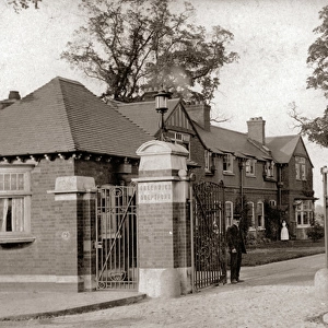
Map of Sidcup and environs

![]()
Wall Art and Photo Gifts from Mary Evans Picture Library
Map of Sidcup and environs
Map of Sidcup and environs - Black and white (negative) lantern slide. Map of Sidcup and environs.. Part of Box 399. Boswell Collection. Date: circa 1900
Mary Evans Picture Library makes available wonderful images created for people to enjoy over the centuries
Media ID 14175172
© The Boswell Collection, Bexley Heritage Trust / Mary Evans
Area Bexley Environs Negative Sidcup Sights Slides Topography
FEATURES IN THESE COLLECTIONS
> Europe
> United Kingdom
> England
> London
> Boroughs
> Bexley
> Maps and Charts
> Early Maps
> Maps and Charts
> Related Images
MADE IN THE USA
Safe Shipping with 30 Day Money Back Guarantee
FREE PERSONALISATION*
We are proud to offer a range of customisation features including Personalised Captions, Color Filters and Picture Zoom Tools
FREE COLORIZATION SERVICE
You can choose advanced AI Colorization for this picture at no extra charge!
SECURE PAYMENTS
We happily accept a wide range of payment options so you can pay for the things you need in the way that is most convenient for you
* Options may vary by product and licensing agreement. Zoomed Pictures can be adjusted in the Cart.