Home > Europe > United Kingdom > England > London > Sights > New River
Inland navigation of England and Wales by

![]()
Wall Art and Photo Gifts from Mary Evans Picture Library
Inland navigation of England and Wales by
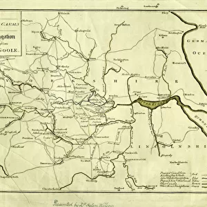
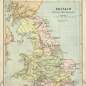
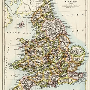
Map of the inland navigation of England and Wales by the canals and principal rivers, 1809. Copperplate engraving by Mutlow from John Mason Goods Pantologia, a New Encyclopedia, G. Kearsley, London, 1813
Mary Evans Picture Library makes available wonderful images created for people to enjoy over the centuries
Media ID 23197972
© Florilegius/Mary Evans
Canals Chart Encyclopedia Freight Good Inland Kearsley Mason Navigation Pantologia Revolution Rivers Waterways Mutlow
FEATURES IN THESE COLLECTIONS
> Arts
> Landscape paintings
> Waterfall and river artworks
> River artworks
> Europe
> United Kingdom
> England
> London
> Related Images
> Europe
> United Kingdom
> England
> London
> Sights
> New River
> Europe
> United Kingdom
> England
> Maps
> Europe
> United Kingdom
> England
> Rivers
> Europe
> United Kingdom
> Wales
> Maps
> Europe
> United Kingdom
> Wales
> Posters
> Europe
> United Kingdom
> Wales
> Rivers
> Historic
> Industrial revolution
> Mary Evans Prints Online
> New Images August 2021
EDITORS COMMENTS
This stunning copperplate engraving, titled 'Map of the Inland Navigation of England and Wales by the Canals and Principal Rivers,' is an intriguing glimpse into the 18th century inland waterway system of England and Wales. The map, published in John Mason Good's Pantologia, A New Encyclopedia in 1813, was created by the skilled hand of engraver Mutlow. The intricate detail of the map reveals the extensive network of canals and rivers that crisscrossed the landscape, providing a vital mode of transport during the Industrial Revolution. The inland waterways were a crucial component of the transportation infrastructure, facilitating the movement of freight and people over long distances more efficiently than the existing roads. The map covers a vast area, from the River Severn in the southwest to the River Tees in the northeast, and from the River Mersey in the northwest to the River Thames in the southeast. The major rivers, such as the Severn, Trent, Mersey, and Thames, are depicted in their entirety, while the numerous canals, including the Grand Union, Trent and Mersey, and the Bridgewater, are shown in detail. The map offers a fascinating insight into the engineering marvels of the time, with locks, weirs, and other navigational structures clearly marked. The intricate network of waterways is a testament to the ingenuity and innovation of the engineers and navigators of the period, who harnessed the power of water to revolutionize transport and commerce. This beautiful copperplate engraving is a valuable historical document, providing a unique perspective on the inland waterways of England and Wales during a period of significant change and development. It is a reminder of the vital role that waterways played in shaping the industrial landscape and connecting communities across the country.
MADE IN THE USA
Safe Shipping with 30 Day Money Back Guarantee
FREE PERSONALISATION*
We are proud to offer a range of customisation features including Personalised Captions, Color Filters and Picture Zoom Tools
SECURE PAYMENTS
We happily accept a wide range of payment options so you can pay for the things you need in the way that is most convenient for you
* Options may vary by product and licensing agreement. Zoomed Pictures can be adjusted in the Cart.