Home > Africa > Libya > Maps
EXPL2A-00317

![]()
Wall Art and Photo Gifts from North Wind
EXPL2A-00317
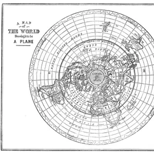
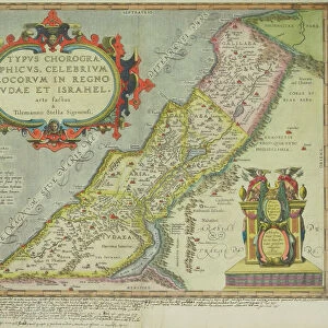
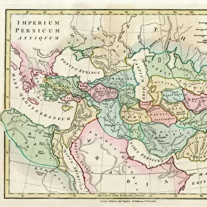
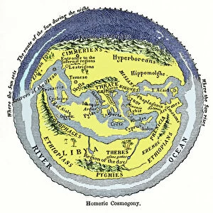
Map of the world according to ancient Greek geographer Eratosthenes.
Hand-colored 19th-century woodcut reproduction
North Wind Picture Archives brings history to life with stock images and hand-colored illustrations
Media ID 5881978
© North Wind Picture Archives
Africa Ancient Ancient Greece Arabia Asia Civilization Classical Earth Europe Flat Earth Greece Greek Navigation Ocean World Eratosthenes Flat Libia Libya
FEATURES IN THESE COLLECTIONS
> Africa
> Libya
> Related Images
> Africa
> Related Images
> Arts
> Artists
> O
> Oceanic Oceanic
> Asia
> Related Images
> Europe
> Greece
> Related Images
> Historic
> Ancient civilizations
> Ancient Greece
> Historic
> Ancient civilizations
> North Wind Picture Archives
> Maps
EDITORS COMMENTS
This print showcases a hand-colored 19th-century woodcut reproduction of the ancient Greek geographer Eratosthenes' map of the world. Steeped in history and classical knowledge, this vintage piece takes us back to a time when exploration and navigation were at their infancy. The intricate illustration depicts an Earth that appears both familiar and foreign, with its continents arranged differently from our modern understanding. Africa, Asia, and Europe take center stage as key players in ancient Greece's worldview, while Libya (now known as Libya) and Arabia are also prominently featured. As we delve into this mesmerizing artwork, we are reminded of the rich civilization that thrived during ancient times. It serves as a testament to human curiosity about our planet's vast oceans and diverse geography. While today we know that the Earth is not flat – contrary to popular belief during Eratosthenes' era – it is fascinating to explore how people perceived their surroundings centuries ago. This artful representation offers us a glimpse into the minds of those who sought to understand their place in this vast world. With its historical significance and artistic allure, this print transports us back in time, inviting contemplation on how far humanity has come in unraveling the mysteries of our planet's past.
MADE IN THE USA
Safe Shipping with 30 Day Money Back Guarantee
FREE PERSONALISATION*
We are proud to offer a range of customisation features including Personalised Captions, Color Filters and Picture Zoom Tools
SECURE PAYMENTS
We happily accept a wide range of payment options so you can pay for the things you need in the way that is most convenient for you
* Options may vary by product and licensing agreement. Zoomed Pictures can be adjusted in the Cart.