Home > Europe > United Kingdom > England > Norfolk > Eastgate
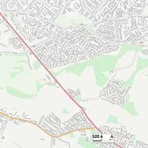
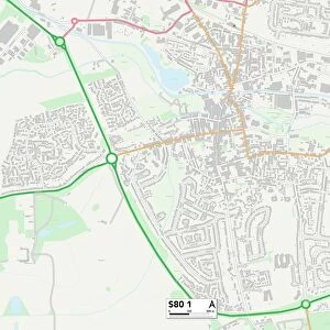
Bassetlaw S80 1 Map

![]()
Wall Art and Photo Gifts from Map Marketing
Bassetlaw S80 1 Map
Postcode Sector Map of Bassetlaw S80 1
Media ID 19980474
Albert Street Albion Close Alder Close Allen Street Almond Grove Ash Close Athelstan Road Bassetlaw Bridge Street Brook Terrace Castle Street Central Avenue Chapel Walk Chestnut Close Cresswell Road Cresswell Street Crown Street Devonshire Street Dock Road Eastgate Edward Street Elms Road Frederick Street George Street Gladstone Place Gladstone Street Grafton Street Hall View Hardy Street Harrington Street Hartland Road Henry Close Hill Street Humber Street John Street King Street Manvers Street Mill Street Newcastle Avenue Norfolk Street Oak Close Park Place Park Street Pine Tree Close Poplar Close Portland Street Rowan Crescent Sandy Lane Shaw Street Sherwood Road Spring Walk Sycamore Close The Willows Trent Street Welbeck Street West Street Westgate Willow Close Water Meadows Worksop
FEATURES IN THESE COLLECTIONS
> Arts
> Artists
> B
> John Brooks
> Arts
> Artists
> E
> Edward Edwards
> Arts
> Artists
> P
> John Pine
> Europe
> United Kingdom
> England
> Norfolk
> Eastgate
> Europe
> United Kingdom
> England
> Norfolk
> Mill Street
> Europe
> United Kingdom
> England
> Norfolk
> Westgate
> Europe
> United Kingdom
> Northern Ireland
> County Down
> Newcastle
> Map Marketing
> Postcode Sector Maps
> S - Sheffield
> Map Marketing
> UK Maps
> Maps and Charts
> Related Images
MADE IN THE USA
Safe Shipping with 30 Day Money Back Guarantee
FREE PERSONALISATION*
We are proud to offer a range of customisation features including Personalised Captions, Color Filters and Picture Zoom Tools
SECURE PAYMENTS
We happily accept a wide range of payment options so you can pay for the things you need in the way that is most convenient for you
* Options may vary by product and licensing agreement. Zoomed Pictures can be adjusted in the Cart.