Home > Europe > United Kingdom > England > London > Towns > Ladywell
East Hertfordshire CM21 9 Map

![]()
Wall Art and Photo Gifts from Map Marketing
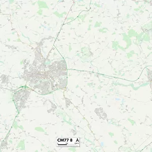
East Hertfordshire CM21 9 Map
Postcode Sector Map of East Hertfordshire CM21 9
Media ID 19967726
Barnard Road Beechfield Bell Street Brook Road Cambridge Road Cedar Close Cherry Gardens Church Street Church Walk East Drive East Hertfordshire East Park Elmwood Fairway Kingsmead Knight Street Lawrence Avenue London Road Lowfield Meadow Way Mill Lane Millfields New Street Newton Drive Northfield Road Parkway Queens Close Rowan Walk School Lane Station Road Sun Street The Drive The Limes The Meadows The Mews The Orchards The Square Walnut Tree Avenue Willow Mead Hedgerows Linwood
FEATURES IN THESE COLLECTIONS
> Arts
> Portraits
> Pop art gallery
> Street art portraits
> Europe
> United Kingdom
> England
> Hertfordshire
> Park Street
> Europe
> United Kingdom
> England
> Hertfordshire
> Reed
> Europe
> United Kingdom
> England
> Hertfordshire
> Related Images
> Europe
> United Kingdom
> England
> Hertfordshire
> Sawbridgeworth
> Europe
> United Kingdom
> England
> London
> Related Images
> Europe
> United Kingdom
> England
> London
> Towns
> Grove Park
> Europe
> United Kingdom
> England
> London
> Towns
> Mill Hill
> Europe
> United Kingdom
> England
> London
> Towns
> Ladywell
> Europe
> United Kingdom
> England
> London
> Towns
> Lower Place
> Map Marketing
> Postcode Sector Maps
> CM - Chelmsford
MADE IN THE USA
Safe Shipping with 30 Day Money Back Guarantee
FREE PERSONALISATION*
We are proud to offer a range of customisation features including Personalised Captions, Color Filters and Picture Zoom Tools
SECURE PAYMENTS
We happily accept a wide range of payment options so you can pay for the things you need in the way that is most convenient for you
* Options may vary by product and licensing agreement. Zoomed Pictures can be adjusted in the Cart.