Home > Europe > United Kingdom > England > London > Boroughs > Croydon
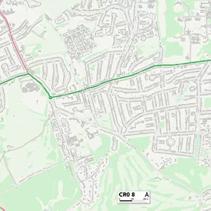
Croydon CR3 6 Map

![]()
Wall Art and Photo Gifts from Map Marketing
Croydon CR3 6 Map
Postcode Sector Map of Croydon CR3 6
Media ID 19968031
Abbots Walk Alderwood Close Beech Grove Beechwood Gardens Beechwood Road Church Hill Church Walk Colin Road Crane Close Crescent Road Croydon Croydon Road Godstone Road Grange Road Greenhill Avenue Greenwood Gardens Highfield Drive Highfield Road Highview Manor Avenue Mead Road Milner Close Milner Road Mount Pleasant Road Oakwood Rise Old School Gardens Park Avenue Park View Priory Mews School Lane Stafford Close Stafford Road Stanstead Road Station Avenue Sutton Close Taunton Avenue The Copse The Crescent The Hill The Riddings Underwood Road Valley Court Waltham Road Woodland Way Woodlands Place Woodside Close Yew Tree Drive Caterham Colliers
FEATURES IN THESE COLLECTIONS
> Animals
> Mammals
> Muridae
> House Mouse
> Architecture
> Towers
> Churches
> Europe
> United Kingdom
> England
> London
> Boroughs
> Croydon
> Europe
> United Kingdom
> Scotland
> Moray
> Elgin
> Map Marketing
> Postcode Sector Maps
> CR - Croydon
> Maps and Charts
> Related Images
MADE IN THE USA
Safe Shipping with 30 Day Money Back Guarantee
FREE PERSONALISATION*
We are proud to offer a range of customisation features including Personalised Captions, Color Filters and Picture Zoom Tools
SECURE PAYMENTS
We happily accept a wide range of payment options so you can pay for the things you need in the way that is most convenient for you
* Options may vary by product and licensing agreement. Zoomed Pictures can be adjusted in the Cart.