Home > Animals > Birds > Waterfowl > Ducks > Gadwall
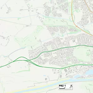
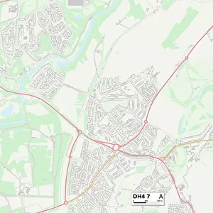
Sunderland DH4 5 Map

![]()
Wall Art and Photo Gifts from Map Marketing
Sunderland DH4 5 Map
Postcode Sector Map of Sunderland DH4 5
Media ID 19968362
Abbey Drive Auckland Close Barley Close Bellflower Close Blind Lane Brandon Close Buckland Close Burnside Burnside Avenue Byland Close Campion Close Cherry Way Cross Street Dairy Lane Ellesmere Close Fairfield Front Street Gladstone Street Greenwood Avenue Harwood Drive Hutton Close Larch Avenue Leyburn Close Leyburn Grove Lime Avenue Linden Grove Lindisfarne Close Longacre Marsden Close Mulberry Way Murray Avenue Newstead Road Phoenix Way Primrose Lane Rosedale Crescent South View Terrace St Andrews St Michaels Stanhope Close Stoneleigh Close Sunderland The Oval Tintern Close Violet Street Wallace Street Willow Road Wingate Close Woodburn Drive Flixton
FEATURES IN THESE COLLECTIONS
> Animals
> Birds
> Waterfowl
> Ducks
> Gadwall
> Animals
> Mammals
> Muridae
> House Mouse
> Arts
> Portraits
> Pop art gallery
> Street art portraits
> Europe
> United Kingdom
> Scotland
> Dumfries and Galloway
> Thornhill
> Europe
> United Kingdom
> Scotland
> Fife
> St Andrews
> Map Marketing
> Postcode Sector Maps
> DH - Durham
> Maps and Charts
> Related Images
MADE IN THE USA
Safe Shipping with 30 Day Money Back Guarantee
FREE PERSONALISATION*
We are proud to offer a range of customisation features including Personalised Captions, Color Filters and Picture Zoom Tools
SECURE PAYMENTS
We happily accept a wide range of payment options so you can pay for the things you need in the way that is most convenient for you
* Options may vary by product and licensing agreement. Zoomed Pictures can be adjusted in the Cart.