Home > Arts > Portraits > Pop art gallery > Street art portraits
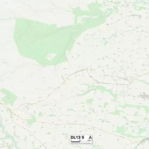
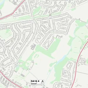
County Durham DL15 8 Map

![]()
Wall Art and Photo Gifts from Map Marketing
County Durham DL15 8 Map
Postcode Sector Map of County Durham DL15 8
Media ID 19968530
Beechwood Lane Bell Street Bridge Street Castle Close Church Street Coniston Crescent County Durham Croft Avenue Croft Street Dawson Street Deneside Derwent Avenue Elliott Street Ennerdale Drive Grasmere Grove Green Lane Greenside Place High Street Hillside Court Langdale Avenue New Road Parkside Patterdale Close Prospect Road Queen Street Railway Street Rydal Drive School Street South Street Station Road The Hollow Ullswater Crescent Vicarage Close Watergate Lane Weavers Croft Woodlands Court Fir Tree
FEATURES IN THESE COLLECTIONS
> Arts
> Portraits
> Pop art gallery
> Street art portraits
> Europe
> United Kingdom
> England
> County Durham
> Durham
> Europe
> United Kingdom
> England
> Durham
> Bedburn
> Europe
> United Kingdom
> England
> Durham
> Deneside
> Europe
> United Kingdom
> England
> Durham
> Durham
> Europe
> United Kingdom
> England
> Durham
> Fir Tree
> Europe
> United Kingdom
> England
> Durham
> Grange Villa
> Europe
> United Kingdom
> England
> Durham
> High Grange
> Europe
> United Kingdom
> England
> Durham
> Hill End
> Europe
> United Kingdom
> England
> Durham
> Parkside
> Map Marketing
> Postcode Sector Maps
> DL - Darlington
MADE IN THE USA
Safe Shipping with 30 Day Money Back Guarantee
FREE PERSONALISATION*
We are proud to offer a range of customisation features including Personalised Captions, Color Filters and Picture Zoom Tools
SECURE PAYMENTS
We happily accept a wide range of payment options so you can pay for the things you need in the way that is most convenient for you
* Options may vary by product and licensing agreement. Zoomed Pictures can be adjusted in the Cart.