Home > Europe > United Kingdom > Scotland > Western Isles > Stornoway
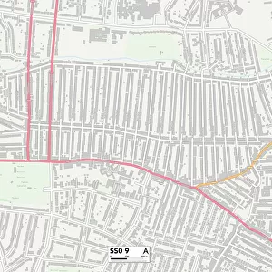
Southend-on-Sea SS2 4 Map

![]()
Wall Art and Photo Gifts from Map Marketing
Southend-on-Sea SS2 4 Map
Postcode Sector Map of Southend-on-Sea SS2 4
Media ID 19978694
Appletree Close Archer Close Arlington Road Beaufort Street Bellevue Road Branksome Road Canterbury Avenue Castleton Road Central Avenue Christchurch Road Crossfield Road Cumberland Avenue Durham Road Eastern Avenue Ely Road Ferndale Road Ferndown Close Grovelands Lawn Avenue Lewes Road Lincoln Close Locksley Close Lonsdale Road Lyme Road Lyndale Avenue North Avenue Norwich Avenue Norwich Close Oban Road Pavilion Close Peartree Close Pelham Road Pilgrims Close Richmond Street Roedean Close Sackville Road Selbourne Road Selwyn Road Sherwood Way South Avenue Southend On Sea St Edmunds Close St Lukes Road The Grove Trinity Road Vaughan Avenue Walsingham Road Westbury Road Moseley Street
FEATURES IN THESE COLLECTIONS
> Arts
> Portraits
> Pop art gallery
> Street art portraits
> Europe
> United Kingdom
> England
> Cumberland
> Europe
> United Kingdom
> England
> Durham
> Durham
> Europe
> United Kingdom
> Scotland
> Highlands
> Wick
> Europe
> United Kingdom
> Scotland
> Strathclyde
> Oban
> Europe
> United Kingdom
> Scotland
> Western Isles
> Stornoway
> Map Marketing
> Postcode Sector Maps
> SS - Southend-on-Sea
> Map Marketing
> UK Maps
> Maps and Charts
> Related Images
MADE IN THE USA
Safe Shipping with 30 Day Money Back Guarantee
FREE PERSONALISATION*
We are proud to offer a range of customisation features including Personalised Captions, Color Filters and Picture Zoom Tools
SECURE PAYMENTS
We happily accept a wide range of payment options so you can pay for the things you need in the way that is most convenient for you
* Options may vary by product and licensing agreement. Zoomed Pictures can be adjusted in the Cart.