
Wall Art and Photo Gifts from Sheffield City Archives
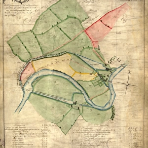
Plan of lands at Grimesthorpe by The Sheffield Gas Company, 1928
Original at Local Studies S21S
Sheffield City Archives and Local Studies Library has an unrivalled collection of images of Sheffield, England
Media ID 14048466
© Sheffield City Council
Anglican
Attercliffe
Bridge
Bridges
Brightside
Brown
Canals
Cemeteries
Cemetery
Church
Churches
Company
Cyclops
Grimesthorpe
Industry
Lane
Maps
River
Rivers
Sheffield
Steel
Viaducts
Works
Abyssinia
Bartholomew
Newhall
MADE IN THE USA
Safe Shipping with 30 Day Money Back Guarantee
FREE PERSONALISATION*
We are proud to offer a range of customisation features including Personalised Captions, Color Filters and Picture Zoom Tools
SECURE PAYMENTS
We happily accept a wide range of payment options so you can pay for the things you need in the way that is most convenient for you
* Options may vary by product and licensing agreement. Zoomed Pictures can be adjusted in the Cart.
redeem
Beautiful Photo Prints and Gifts
image
Professionally Printed
inventory
Photo Prints are in stock
thumb_up
Professional quality finish
diamond
Made with high-grade materials
inventory_2
Carefully packed to aid safe arrival
Related Images
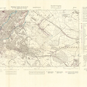
North Sheffield marked with bombing targets, c. 1940
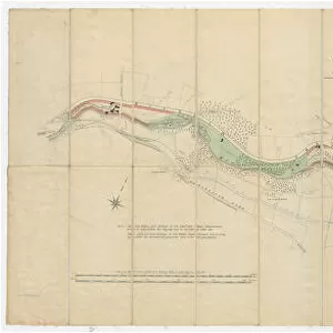
A map of Attercliffe Forge and the Farm, Tenements etc annxed thereto... belonging to the Duke of Norfolk and... Eliz Fell, 1768
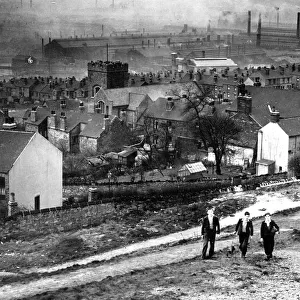
View over Wincobank and Brightside, Sheffield, Yorkshire, 1940s - 1950s
Ordnance Survey map of north Sheffield copied by the Germans, and marked with bombing targets
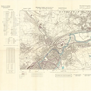
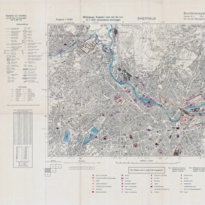
Ordnance Survey map of east end of Sheffield (and Rotherham) copied by the Germans, and marked with bombing targets

Mousehole Forge, Rivelin Valley, Rivelin, c. 1825
![The Duke of Norfolks estates in Brightside Bierlow, Sheffield, [mid 19th cent]](/sq/716/duke-norfolks-estates-brightside-bierlow-20355002.jpg.webp)
The Duke of Norfolks estates in Brightside Bierlow, Sheffield, [mid 19th cent]
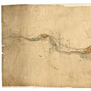
Plan of the Rivelin Valley from Rivelin Mill to Hollins Bridge, c. 1814
![A map of Wm. Carrs Farm at Stanington [Stannington], 1747](/sq/716/map-wm-carrs-farm-stanington-stannington-1747-19192400.jpg.webp)
A map of Wm. Carrs Farm at Stanington [Stannington], 1747
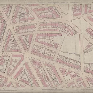
Ordnance Survey Map, Somerset Street area, Burngreave, Sheffield, 1889 (Yorkshire sheet no. 294. 4. 22)
Contoured plan of Rivelin Valley Road, Sheffield, Yorkshire, c. 1900
![A map of the lands near Attercliffe and Darnall, [?1820s]](/sq/716/map-lands-near-attercliffe-darnall-1820s-18396317.jpg.webp)
A map of the lands near Attercliffe and Darnall, [?1820s]

