Home > Arts > Portraits > Pop art gallery > Street art portraits
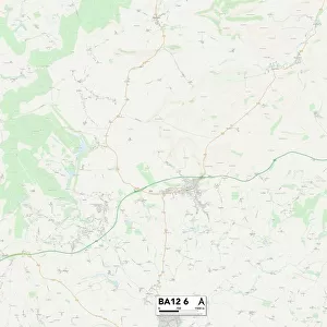
Mendip BA11 6 Map

![]()
Wall Art and Photo Gifts from Map Marketing
Mendip BA11 6 Map
Postcode Sector Map of Mendip BA11 6
Media ID 19965720
Bath Road Bradford Road Church Hill Church Lane Church Row Church Street Churchfields Clay Lane Coopers Lane Crooked Lane Fairfield Frome Road High Street Homefield Close Langham Place Lower Street Marsh Road Mendip Mill Lane Parkgate Lane Sandy Lane Spinners Close St Lukes Road Straight Lane Stubbs Lane The Mead The Weavers Valley View Walnut Close Warminster Road Cheap Street Rode Rylands The Sportsman
FEATURES IN THESE COLLECTIONS
> Arts
> Portraits
> Pop art gallery
> Street art portraits
> Map Marketing
> Postcode Sector Maps
> BA - Bath
> Map Marketing
> UK Maps
> Maps and Charts
> Related Images
MADE IN THE USA
Safe Shipping with 30 Day Money Back Guarantee
FREE PERSONALISATION*
We are proud to offer a range of customisation features including Personalised Captions, Color Filters and Picture Zoom Tools
SECURE PAYMENTS
We happily accept a wide range of payment options so you can pay for the things you need in the way that is most convenient for you
* Options may vary by product and licensing agreement. Zoomed Pictures can be adjusted in the Cart.