Home > Europe > United Kingdom > England > Suffolk > Lowestoft
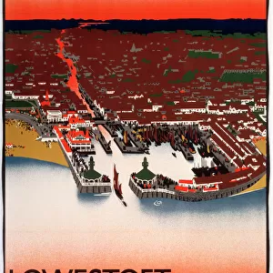
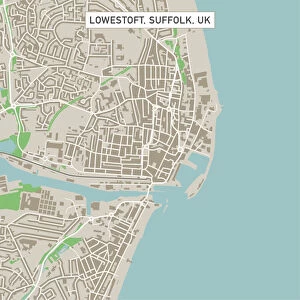
Lowestoft Suffolk UK City Street Map

![]()
Wall Art and Photo Gifts from Fine Art Storehouse
Lowestoft Suffolk UK City Street Map
Vector Illustration of a City Street Map of Lowestoft, Suffolk, UK. Included files are EPS (v10) and Hi-Res JPG.
Data courtesy from Ordnance Survey: VectorMap District
https:/ordnancesurvey.co.uk/business-and-government/products/vectormap-district.html
OS OpenData is free to use under the Open Government Licence (OGL).
Contains OS data eCrown copyright and database right 2017.
http:/nationalarchives.gov.uk/doc/open-government-licence/version/3/
Unleash your creativity and transform your space into a visual masterpiece!
Frank Ramspott
Media ID 15055267
© Frank Ramspott, all rights reserved
Aerial View Computer Graphic Directly Above Gray Green Road Map Street Map Suffolk Text Digitally Generated Image Lowestoft
FEATURES IN THESE COLLECTIONS
> Aerial Photography
> Related Images
> Arts
> Contemporary art
> Digital artwork
> Street art
> Arts
> Portraits
> Pop art gallery
> Street art portraits
> Arts
> Street art graffiti
> Digital art
> Digital paintings
> Arts
> Street art graffiti
> Digital art
> Vector illustrations
> Europe
> United Kingdom
> England
> Suffolk
> Lowestoft
> Europe
> United Kingdom
> England
> Suffolk
> Related Images
> Europe
> United Kingdom
> Maps
> Fine Art Storehouse
> Map
> Street Maps
> Maps and Charts
> Related Images
EDITORS COMMENTS
This print showcases a meticulously crafted city street map of Lowestoft, Suffolk, UK. The vector illustration captures the intricate details of this charming coastal town, allowing you to explore its every nook and cranny. With included files in EPS (v10) and Hi-Res JPG formats, you can easily access and utilize this artwork for various purposes. The data used to create this masterpiece is courtesy of Ordnance Survey's VectorMap District. This reliable source ensures accuracy and authenticity in depicting the streets, buildings, roads, and overall cartography of Lowestoft. It's worth noting that OS OpenData has generously made their information available under the Open Government Licence (OGL), promoting free usage for all. In this digitally generated image captured by Frank Ramspott from Fine Art Storehouse, we are presented with an aerial view directly above the city streets. The color palette consists of shades of gray, green, blue, and white - creating a visually appealing contrast against each other. Whether you're a local resident or simply fascinated by maps and design elements alike, this print offers an immersive experience into the physical geography of Lowestoft. So dive into its intricacies without hesitation as it beautifully encapsulates the essence of this picturesque seaside town.
MADE IN THE USA
Safe Shipping with 30 Day Money Back Guarantee
FREE PERSONALISATION*
We are proud to offer a range of customisation features including Personalised Captions, Color Filters and Picture Zoom Tools
SECURE PAYMENTS
We happily accept a wide range of payment options so you can pay for the things you need in the way that is most convenient for you
* Options may vary by product and licensing agreement. Zoomed Pictures can be adjusted in the Cart.