Home > Animals > Birds > Waterfowl > Ducks > Ringed Teal
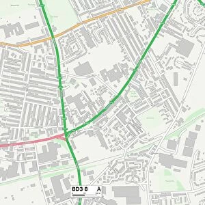
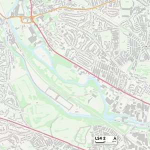
Leeds LS10 3 Map

![]()
Wall Art and Photo Gifts from Map Marketing
Leeds LS10 3 Map
Postcode Sector Map of Leeds LS10 3
Media ID 19974858
Blackthorn Court Blakeney Road Broom Crescent Broom Grove Broom Place Broom Road Chapel Hill Clayton Close Clayton Drive Clayton Road Darley Avenue Dunlin Drive Enterprise Way Exeter Drive Leeds Lindale Close Lonsdale Close Manor Farm Close Manor Farm Drive Manor Farm Road Middleton Middleton Road New Lane Newhall Road Orion Drive Rosedale Gardens Sanderling Way South View Road St Philips Avenue Town Street Wakefield Road Ward Lane Westbury Street Windmill Close Windmill Road
FEATURES IN THESE COLLECTIONS
> Animals
> Birds
> Charadriiformes
> Sandpipers
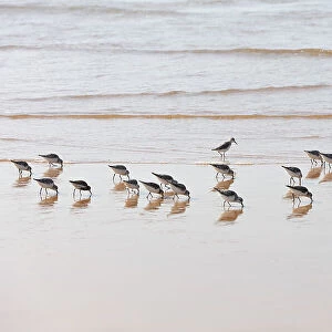
> Dunlin
> Animals
> Birds
> Charadriiformes
> Sandpipers
> Sanderling
> Animals
> Birds
> Waterfowl
> Ducks
> Ringed Teal
> Arts
> Artists
> L
> Philip Lea
> Map Marketing
> Postcode Sector Maps
> LS - Leeds
> Maps and Charts
> Related Images
> Popular Themes
> Railway Posters
MADE IN THE USA
Safe Shipping with 30 Day Money Back Guarantee
FREE PERSONALISATION*
We are proud to offer a range of customisation features including Personalised Captions, Color Filters and Picture Zoom Tools
SECURE PAYMENTS
We happily accept a wide range of payment options so you can pay for the things you need in the way that is most convenient for you
* Options may vary by product and licensing agreement. Zoomed Pictures can be adjusted in the Cart.