Home > Europe > United Kingdom > England > London > Boroughs > Ealing
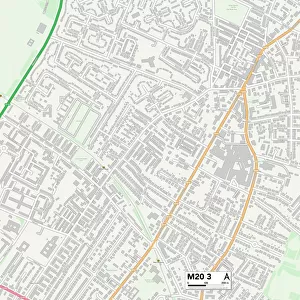
Manchester M19 1 Map

![]()
Wall Art and Photo Gifts from Map Marketing
Manchester M19 1 Map
Postcode Sector Map of Manchester M19 1
Media ID 19975765
Avon Road Baldock Road Baldwin Road Barnfield Road Blackthorn Avenue Bolton Avenue Church Lane Dahlia Close Elmhurst Drive Glendale Avenue Glenhurst Road Green End Road Greenacres Drive Harwood Road Hatfield Avenue Hawthorn Drive Kenwood Avenue Kingsway Lane End Road Leyland Avenue Manchester Milton Court Norwood Avenue Oakland Avenue Oakleigh Avenue Poplar Road Queensway St Margarets Avenue Thornfield Road Watford Road Westcroft Road Woodcroft Avenue Woodside Avenue
FEATURES IN THESE COLLECTIONS
> Europe
> United Kingdom
> England
> Avon
> Europe
> United Kingdom
> England
> London
> Boroughs
> Ealing
> Europe
> United Kingdom
> England
> London
> Boroughs
> Enfield
> Europe
> United Kingdom
> England
> London
> Boroughs
> Harrow
> Europe
> United Kingdom
> England
> London
> Sights
> Hyde Park
> Europe
> United Kingdom
> England
> Manchester
> Burnage
> Europe
> United Kingdom
> England
> Manchester
> Hyde
> Europe
> United Kingdom
> England
> Manchester
> Manchester
> Map Marketing
> Postcode Sector Maps
> M - Manchester
> Maps and Charts
> Related Images
MADE IN THE USA
Safe Shipping with 30 Day Money Back Guarantee
FREE PERSONALISATION*
We are proud to offer a range of customisation features including Personalised Captions, Color Filters and Picture Zoom Tools
SECURE PAYMENTS
We happily accept a wide range of payment options so you can pay for the things you need in the way that is most convenient for you
* Options may vary by product and licensing agreement. Zoomed Pictures can be adjusted in the Cart.