Home > Europe > United Kingdom > England > London > Boroughs > Bromley
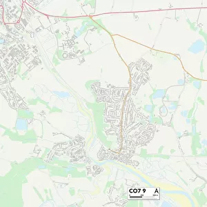
Tendring CO16 7 Map

![]()
Wall Art and Photo Gifts from Map Marketing
Tendring CO16 7 Map
Postcode Sector Map of Tendring CO16 7
Media ID 19968716
Aster Close Bluebell Avenue Bromley Close Carters Close Chandlers Close Chestnut Avenue Crocus Close Curtis Close Dahlia Close Edgware Road Elm Grove Farmers Way Hyacinth Close Mason Road Oak Avenue Oak Tree Drive Seymour Road St Ives Close Tendring The Spinney Woodlands
FEATURES IN THESE COLLECTIONS
> Europe
> United Kingdom
> England
> London
> Boroughs
> Bromley
> Map Marketing
> Postcode Sector Maps
> CO - Colchester
> Maps and Charts
> Related Images
> North America
> United States of America
> New York
> New York
> Brooklyn
> Marine Park
MADE IN THE USA
Safe Shipping with 30 Day Money Back Guarantee
FREE PERSONALISATION*
We are proud to offer a range of customisation features including Personalised Captions, Color Filters and Picture Zoom Tools
SECURE PAYMENTS
We happily accept a wide range of payment options so you can pay for the things you need in the way that is most convenient for you
* Options may vary by product and licensing agreement. Zoomed Pictures can be adjusted in the Cart.