Home > Europe > United Kingdom > Scotland > Dumfries and Galloway > Monreith
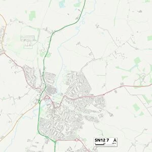
East Dunbartonshire G61 1 Map

![]()
Wall Art and Photo Gifts from Map Marketing
East Dunbartonshire G61 1 Map
Postcode Sector Map of East Dunbartonshire G61 1
Media ID 19970993
Almond Road Balmoral Drive Coronation Way Deveron Road East Dunbartonshire Eskdale Road Fernlea Jackson Place Lochend Road Lomond Road Maxwell Avenue Murrayfield Drive North View Old Farm Road Somerford Road Spey Road Stirling Avenue Tay Road West End Westfield Crescent Westfield Drive Wheatfield Road Forth Road Hollymount
FEATURES IN THESE COLLECTIONS
> Europe
> United Kingdom
> Scotland
> Aberdeenshire
> Ballater
> Europe
> United Kingdom
> Scotland
> Aberdeenshire
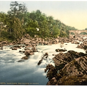
> Banchory
> Europe
> United Kingdom
> Scotland
> Bute
> Europe
> United Kingdom
> Scotland
> Dumfries and Galloway
> Annan
> Europe
> United Kingdom
> Scotland
> Dumfries and Galloway
> Monreith
> Europe
> United Kingdom
> Scotland
> Falkirk
> Carron
> Europe
> United Kingdom
> Scotland
> Highlands
> Dornoch
> Europe
> United Kingdom
> Scotland
> Stirlingshire
> Stirling
> Map Marketing
> Postcode Sector Maps
> G - Glasgow
> Maps and Charts
> Related Images
MADE IN THE USA
Safe Shipping with 30 Day Money Back Guarantee
FREE PERSONALISATION*
We are proud to offer a range of customisation features including Personalised Captions, Color Filters and Picture Zoom Tools
SECURE PAYMENTS
We happily accept a wide range of payment options so you can pay for the things you need in the way that is most convenient for you
* Options may vary by product and licensing agreement. Zoomed Pictures can be adjusted in the Cart.