Home > Europe > United Kingdom > England > London > Boroughs > Hillingdon
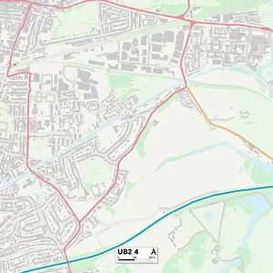
Hillingdon UB7 0 Map

![]()
Wall Art and Photo Gifts from Map Marketing
Hillingdon UB7 0 Map
Postcode Sector Map of Hillingdon UB7 0
Media ID 19979950
Cambridge Close Chestnut Close Hatch Lane High Street Hillingdon Holloway Lane Kenwood Close Longford Monks Way Moor Lane Moorland Road Newbury Road Newport Road Northwood Road Priory Way Russell Gardens Saxon Way School Road Summerhouse Lane The Square Vincent Close Wilton Close Wykeham Close Sipson
FEATURES IN THESE COLLECTIONS
> Europe
> United Kingdom
> England
> London
> Boroughs
> Hillingdon
> Europe
> United Kingdom
> Wales
> Gwent
> Newport
> Europe
> United Kingdom
> Wales
> Pembrokeshire
> Newport
> Map Marketing
> Postcode Sector Maps
> UB - Uxbridge
> Maps and Charts
> Related Images
MADE IN THE USA
Safe Shipping with 30 Day Money Back Guarantee
FREE PERSONALISATION*
We are proud to offer a range of customisation features including Personalised Captions, Color Filters and Picture Zoom Tools
SECURE PAYMENTS
We happily accept a wide range of payment options so you can pay for the things you need in the way that is most convenient for you
* Options may vary by product and licensing agreement. Zoomed Pictures can be adjusted in the Cart.