Home > Europe > United Kingdom > England > West Yorkshire > Halifax
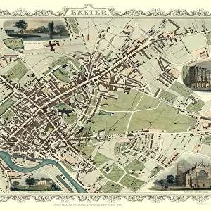
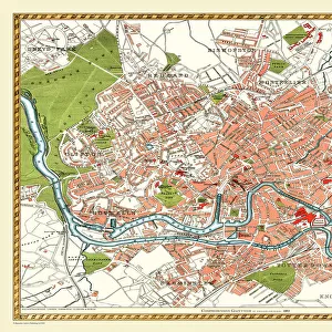
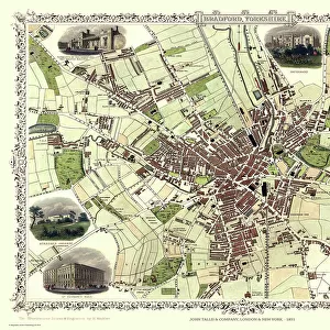
Old Map of Bradford 1851 by John Tallis

![]()
Wall Art and Photo Gifts from MapSeeker
Old Map of Bradford 1851 by John Tallis
In this John Tallis 1851 map of Bradford in west Yorkshire the railways are now well established, buildings now stretch out from the centre of Bradford along the main artery roads. There are no fewer than seven illustrations on the plan of Bradford, Yorkshire. These illustrations are of the Terminus of the Bradford and Halifax Railway, Infirmary Cemetery, St Peters Church, Roman Catholic Church, Airdale College and St Georges Hall
Welcome to the Mapseeker Image library and enter an historic gateway to one of the largest on-line collections of Historic Maps, Nostalgic Views, Vista's and Panorama's from a World gone by.
Media ID 20347638
Historic Map John Tallis John Tallis Map Old Town Plan Tallis Map Bradford Bradford City
FEATURES IN THESE COLLECTIONS
> Animals
> Mammals
> Muridae
> Peters Mouse
> Arts
> Artists
> T
> John Tallis
> Europe
> United Kingdom
> England
> West Yorkshire
> Bradford
> Europe
> United Kingdom
> England
> West Yorkshire
> Halifax
> Europe
> United Kingdom
> England
> West Yorkshire
> Related Images
> Europe
> United Kingdom
> England
> Yorkshire
> Bradford
> Europe
> United Kingdom
> England
> Yorkshire
> Halifax
> Europe
> United Kingdom
> England
> Yorkshire
> Old Town
> Europe
> United Kingdom
> England
> Yorkshire
> Related Images
> Europe
> United Kingdom
> England
> Yorkshire
> Well
> MapSeeker
> British Town And City Plans
> English & Welsh PORTFOLIO
EDITORS COMMENTS
This print showcases an exquisite piece of history - the Old Map of Bradford from 1851, meticulously crafted by John Tallis. Transporting us back in time, this map reveals a bustling town with well-established railways and buildings extending along the main roads. The attention to detail is truly remarkable. What makes this map even more fascinating are the seven illustrations adorning its surface. Each illustration offers a glimpse into different aspects of life in Bradford during that era. From the impressive Terminus of the Bradford and Halifax Railway to the serene Infirmary Cemetery, these images bring forth a sense of nostalgia and curiosity about what once was. The religious landmarks featured on this map also hold significance within the community. St Peters Church stands tall as a symbol of faith, while the Roman Catholic Church represents diversity and inclusivity. Airdale College serves as a testament to education's importance, while St Georges Hall exudes grandeur and elegance. As we explore this old town plan, it becomes evident how much has changed over time while appreciating how certain elements have stood steadfast throughout history. This historic map not only provides valuable insights into Bradford's past but also sparks our imagination about its evolution into the vibrant city it is today.
MADE IN THE USA
Safe Shipping with 30 Day Money Back Guarantee
FREE PERSONALISATION*
We are proud to offer a range of customisation features including Personalised Captions, Color Filters and Picture Zoom Tools
SECURE PAYMENTS
We happily accept a wide range of payment options so you can pay for the things you need in the way that is most convenient for you
* Options may vary by product and licensing agreement. Zoomed Pictures can be adjusted in the Cart.