Home > Africa > Ethiopia (Abyssinia) > Maps
Map / Africa / Ethiopia 18C

![]()
Wall Art and Photo Gifts from Mary Evans Picture Library
Map / Africa / Ethiopia 18C
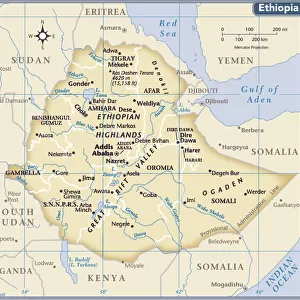
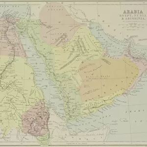
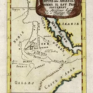
Map of Ethiopia (Abyssinia)
Mary Evans Picture Library makes available wonderful images created for people to enjoy over the centuries
Media ID 608767
© Mary Evans Picture Library 2015 - https://copyrighthub.org/s0/hub1/creation/maryevans/MaryEvansPictureID/10113842
FEATURES IN THESE COLLECTIONS
> Africa
> Ethiopia (Abyssinia)
> Maps
> Africa
> Ethiopia (Abyssinia)
> Related Images
> Africa
> Ethiopia
> Related Images
> Africa
> Related Images
> Maps and Charts
> Early Maps
> Maps and Charts
> Related Images
EDITORS COMMENTS
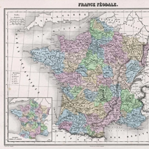
This historic map print, titled "Abyssinia or Ethiopia in Africa," dates back to the early 18th century, specifically 1719. The map provides a fascinating glimpse into the geographical knowledge of Ethiopia and the Horn of Africa during this period. Ethiopia, also known as Abyssinia, is depicted with intricate detail, showcasing its various provinces, rivers, and mountains. The map was created during a time when European exploration and cartography were advancing rapidly, yet Ethiopia remained largely unknown to the Western world. This map, therefore, reflects the limited information available about the region at the time. The cartographer's understanding of the geography of Ethiopia was influenced by ancient Greek and Roman texts, as well as accounts from travelers and missionaries. Despite the inaccuracies and misconceptions present in the map, it remains an important historical document. The map's depiction of Ethiopia as a powerful and independent kingdom, rather than a European colony, reflects the reality of the region's political status during this era. Ethiopia was one of the few African states that successfully resisted European colonization, maintaining its sovereignty throughout the 19th century. The map also highlights the significance of Ethiopia as a center of Christianity in Africa. The Ethiopian Orthodox Church, which traces its origins back to the 4th century, is the oldest independent Christian church in the world. The map shows various Christian sites and regions within Ethiopia, reflecting the deep religious history of the country. Overall, this map print offers a captivating window into the history of Ethiopia and the Horn of Africa during the 18th century. Its intricate details and historical significance make it an essential addition to any collection of historical maps or African studies.
MADE IN THE USA
Safe Shipping with 30 Day Money Back Guarantee
FREE PERSONALISATION*
We are proud to offer a range of customisation features including Personalised Captions, Color Filters and Picture Zoom Tools
SECURE PAYMENTS
We happily accept a wide range of payment options so you can pay for the things you need in the way that is most convenient for you
* Options may vary by product and licensing agreement. Zoomed Pictures can be adjusted in the Cart.