Home > Europe > United Kingdom > England > London > Sights > St James Park
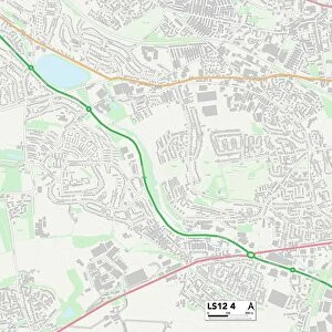
Leeds LS12 3 Map

![]()
Wall Art and Photo Gifts from Map Marketing
Leeds LS12 3 Map
Postcode Sector Map of Leeds LS12 3
Media ID 19974898
Aberdeen Road Albany Street Albany Terrace Alliance Street Christ Church Road Claremont Place Claremont Street Claremont Terrace College View Cross Lane Edinburgh Avenue Edinburgh Place Edinburgh Road Greenock Road Heights Lane Hill Top Close Hill Top Road Leeds Marsden Street Moorfield Avenue Moorfield Road Moorfield Street Oban Street Park Avenue Park Crescent Park Road Park Street Pinfold Lane Poplar Close St James Close Station Crescent Station Road Station Way Swallow Close Swallow Crescent Thornton Avenue Thornton Grove Tower Lane Tower Place Town Street Weavers Court Westfield Avenue Windmill Court Wortley Road
FEATURES IN THESE COLLECTIONS
> Animals
> Fishes
> S
> Swallower
> Animals
> Insects
> Spiders
> Silver Garden
> Architecture
> Towers
> Churches
> Europe
> United Kingdom
> England
> London
> Sights
> St James Park
> Europe
> United Kingdom
> Heritage Sites
> Old and New Towns of Edinburgh
> Europe
> United Kingdom
> Scotland
> Aberdeenshire
> Aberdeen
> Europe
> United Kingdom
> Scotland
> Edinburgh
> Edinburgh
> Europe
> United Kingdom
> Scotland
> Lothian
> Edinburgh
> Europe
> United Kingdom
> Scotland
> Strathclyde
> Greenock
> Europe
> United Kingdom
> Scotland
> Strathclyde
> Oban
> Map Marketing
> Postcode Sector Maps
> LS - Leeds
MADE IN THE USA
Safe Shipping with 30 Day Money Back Guarantee
FREE PERSONALISATION*
We are proud to offer a range of customisation features including Personalised Captions, Color Filters and Picture Zoom Tools
SECURE PAYMENTS
We happily accept a wide range of payment options so you can pay for the things you need in the way that is most convenient for you
* Options may vary by product and licensing agreement. Zoomed Pictures can be adjusted in the Cart.