Home > Animals > Birds > Passerines > Larks > Related Images
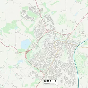
Worcester WR5 2 Map

![]()
Wall Art and Photo Gifts from Map Marketing
Worcester WR5 2 Map
Postcode Sector Map of Worcester WR5 2
Media ID 19982712
Arran Place Arundel Drive Athelstan Road Bath Road Battle Road Berkeley Close Blake Street Cannon Street Cherry Street Church Lane Cooke Close Cromwell Crescent Eden Court Fox Lane Goodwood Avenue Goodwood Close Hailsham Close Littleworth Livingstone Street London Road Marlborough Street Midhurst Close Norton Norton Road Orchard Grove Pevensey Close Prospect Place Red Hill Red Hill Lane Romney Way Rose Avenue Rose Bank St Dunstans Close St James Close The Croft The Ridgeway Walkers Lane Whittington Whittington Road Worcester Broomhall Hatfield
FEATURES IN THESE COLLECTIONS
> Animals
> Birds
> Passerines
> Larks
> Related Images
> Animals
> Mammals
> Cervidae
> Red Deer
> Animals
> Mammals
> Dogs (Wild)
> Red Fox
> Arts
> Artists
> W
> James Walker
> Arts
> Portraits
> Pop art gallery
> Street art portraits
> Europe
> United Kingdom
> England
> London
> Related Images
> Europe
> United Kingdom
> England
> London
> Sights
> Green Park
> Europe
> United Kingdom
> England
> London
> Sights
> St James Park
> Europe
> United Kingdom
> England
> London
> Towns
> Church End
> Map Marketing
> Postcode Sector Maps
> WR - Worcester
MADE IN THE USA
Safe Shipping with 30 Day Money Back Guarantee
FREE PERSONALISATION*
We are proud to offer a range of customisation features including Personalised Captions, Color Filters and Picture Zoom Tools
SECURE PAYMENTS
We happily accept a wide range of payment options so you can pay for the things you need in the way that is most convenient for you
* Options may vary by product and licensing agreement. Zoomed Pictures can be adjusted in the Cart.