Home > Animals > Insects > Related Images
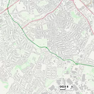
South Derbyshire DE11 8 Map

![]()
Wall Art and Photo Gifts from Map Marketing
South Derbyshire DE11 8 Map
Postcode Sector Map of South Derbyshire DE11 8
Media ID 19969619
Albion Street Anchor Close Belmont Street Bernard Street Bishops Gate Bluebell Grove Bourne Way Briar Close Bridge Close Bridge Street Butt Lane Chapel Street Church Close Church Street Derby Road Edward Street Forest Road Frederick Street Hall Close Hall Farm Close Hall Farm Road Heath Lane Hepworth Road High Street Hill Street John Street Kiln Way Main Street Mansfield Close New Road North Close Occupation Lane Occupation Road Parkers Close Pool Street Rowley Close Russell Street School Close South Close South Derbyshire Stanley Street Station Crescent Strawberry Lane The Close Thompson Close Vicarage Close Vicarage Gardens Vicarage Road Victoria Drive Well Lane Windmill Close Woodhouse Street
FEATURES IN THESE COLLECTIONS
> Animals
> Insects
> Related Images
> Animals
> Mammals
> Muridae
> Heath Mouse
> Architecture
> Tunnels
> Arts
> Artists
> C
> Edward Clay
> Arts
> Artists
> C
> Frederick Church
> Arts
> Artists
> H
> John Hillers
> Arts
> Artists
> H
> John Hills
> Arts
> Artists
> P
> John Parker
> Arts
> Artists
> R
> John Russell
> Arts
> Artists
> W
> Frank Weller
> Map Marketing
> Postcode Sector Maps
> DE - Derby
MADE IN THE USA
Safe Shipping with 30 Day Money Back Guarantee
FREE PERSONALISATION*
We are proud to offer a range of customisation features including Personalised Captions, Color Filters and Picture Zoom Tools
SECURE PAYMENTS
We happily accept a wide range of payment options so you can pay for the things you need in the way that is most convenient for you
* Options may vary by product and licensing agreement. Zoomed Pictures can be adjusted in the Cart.