Home > Europe > United Kingdom > Scotland > Aberdeenshire > Huntly
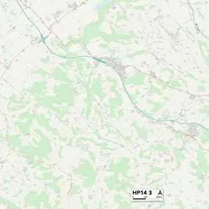
Wycombe HP14 4 Map

![]()
Wall Art and Photo Gifts from Map Marketing
Wycombe HP14 4 Map
Postcode Sector Map of Wycombe HP14 4
Media ID 19972060
Allen Drive Ash Close Beech Park Bottom Road Bowers Lane Braeside Burnham Road Chapel Lane Cherry Tree Close Chiltern View Christopher Close Church Lane City Road Coombe Lane Fleet Close Forge Road Green End Green End Road Green Lane Hatch Lane Haw Lane Hillview Laurel Drive Main Road Moseley Road New Road Orchard Close Park Lane Parkside Slough Lane Stocking Lane The Coppice The Crest The Glebe The Orchard Valley Road Virginia Gardens Wedgwood Drive Whitfield Road Willow Court Windmill Lane Woodland View Woodlands Drive Wycombe Wycombe Road Brackenwood Bradenham Parkwood The City
FEATURES IN THESE COLLECTIONS
> Animals
> Mammals
> Phyllostomidae
> Tree Bat
> Europe
> United Kingdom
> Scotland
> Aberdeenshire
> Huntly
> Map Marketing
> Postcode Sector Maps
> HP - Hemel Hempstead
> Maps and Charts
> Related Images
MADE IN THE USA
Safe Shipping with 30 Day Money Back Guarantee
FREE PERSONALISATION*
We are proud to offer a range of customisation features including Personalised Captions, Color Filters and Picture Zoom Tools
SECURE PAYMENTS
We happily accept a wide range of payment options so you can pay for the things you need in the way that is most convenient for you
* Options may vary by product and licensing agreement. Zoomed Pictures can be adjusted in the Cart.