Home > Europe > United Kingdom > Wales > Flintshire > Buckley
Leeds LS11 6 Map

![]()
Wall Art and Photo Gifts from Map Marketing
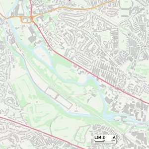
Leeds LS11 6 Map
Postcode Sector Map of Leeds LS11 6
Media ID 19974850
Beverley Avenue Bude Road Burlington Road Clovelly Avenue Colwyn Avenue Colwyn Road Dawson Road Folly Lane Hardy Street Hill Street Ingleton Close Leeds Linden Avenue Linden Gardens Linden Grove Linden Place Linden Road Linden Street Lodge Lane Malvern Grove Rowland Road Sefton Street St Francis Close Stratford Street Tempest Road Trentham Avenue Westbourne Avenue Westbourne Place Westbourne Street Wickham Street Woodview Road
FEATURES IN THESE COLLECTIONS
> Arts
> Artists
> P
> Francis Place
> Europe
> United Kingdom
> Scotland
> Aberdeenshire
> Maud
> Europe
> United Kingdom
> Wales
> Flintshire
> Buckley
> Map Marketing
> Postcode Sector Maps
> LS - Leeds
> Maps and Charts
> Related Images
MADE IN THE USA
Safe Shipping with 30 Day Money Back Guarantee
FREE PERSONALISATION*
We are proud to offer a range of customisation features including Personalised Captions, Color Filters and Picture Zoom Tools
SECURE PAYMENTS
We happily accept a wide range of payment options so you can pay for the things you need in the way that is most convenient for you
* Options may vary by product and licensing agreement. Zoomed Pictures can be adjusted in the Cart.