Home > Europe > United Kingdom > England > London > Boroughs > Hounslow
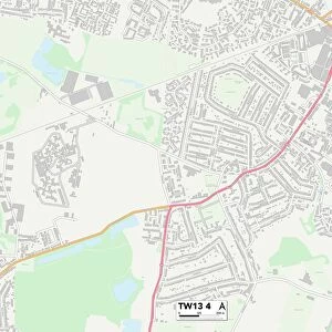
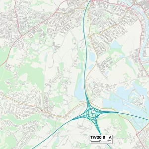
Hounslow TW13 7 Map

![]()
Wall Art and Photo Gifts from Map Marketing
Hounslow TW13 7 Map
Postcode Sector Map of Hounslow TW13 7
Media ID 19982280
April Close Aspen Way Badger Close Brookside Close Castle Way Chestnut Way Church Road Clifton Avenue Deerhurst Close Elizabeth Way Elmwood Avenue Forest Road Foxwood Close Harvest Road Hounslow Huntsmans Close Juniper Close Ludlow Road Maple Way Mulberry Close Parkfield Avenue Parkfield Crescent Parkfield Road Pinewood Road Poplar Way Queens Avenue Queens Way Roebuck Close Seymour Gardens Shakespeare Way Sycamore Close Tawny Close
FEATURES IN THESE COLLECTIONS
> Arts
> Landscape paintings
> Forest and woodland scenes
> Forest artwork
> Europe
> United Kingdom
> England
> London
> Boroughs
> Hounslow
> Map Marketing
> Postcode Sector Maps
> TW - Twickenham
> Maps and Charts
> Related Images
MADE IN THE USA
Safe Shipping with 30 Day Money Back Guarantee
FREE PERSONALISATION*
We are proud to offer a range of customisation features including Personalised Captions, Color Filters and Picture Zoom Tools
SECURE PAYMENTS
We happily accept a wide range of payment options so you can pay for the things you need in the way that is most convenient for you
* Options may vary by product and licensing agreement. Zoomed Pictures can be adjusted in the Cart.