Home > Animals > Mammals > Muridae > Fortior
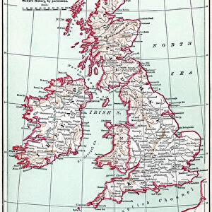
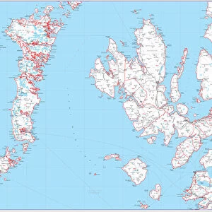
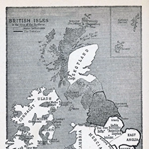
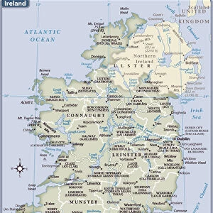
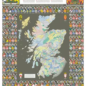
Map of the British Isles, 1946. Creator: Unknown

![]()
Wall Art and Photo Gifts from Heritage Images
Map of the British Isles, 1946. Creator: Unknown
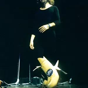
Map of the British Isles, 1946. Map of England, Wales, Ireland and Scotland, Showing the Chief Places Mentioned in the Text, ie islands off the coast including Holy Island, the Farne Islands, Mersea, Canvey and Sheppey, Isle of Wight, Isles of Scilly, Lundy, Skomer, Anglesey, the Skerries, Isle of Man, Great Blasket, the Outer Hebrides, the Orkneys and the Shetlands. From " Islands Round Britain", by R. M. Lockley. [Collins, London, 1946]
Heritage Images features heritage image collections
Media ID 19777308
© The Print Collector/Heritage Images
Bamp W Britain In Pictures British Isles Coastline Collins Great Britain Island Islands Lockley R M Lockley Ronald Ronald Lockley Ronald Mathias Ronald Mathias Lockley Social History William Collins William Collins And Sons William Collins Sons
FEATURES IN THESE COLLECTIONS
> Animals
> Mammals
> Muridae
> Fortior
> Arts
> Artists
> C
> William Collins
> Arts
> Artists
> I
> William Ireland
> Arts
> Artists
> W
> William White
> Europe
> Republic of Ireland
> Maps
> Europe
> United Kingdom
> England
> Maps
> Europe
> United Kingdom
> Scotland
> Maps
> Europe
> United Kingdom
> Scotland
> Orkney
> Europe
> United Kingdom
> Scotland
> Posters
> Europe
> United Kingdom
> Scotland
> Related Images
EDITORS COMMENTS
This print showcases a detailed map of the British Isles from 1946. The creator of this remarkable piece remains unknown, but their intricate depiction of England, Wales, Ireland, and Scotland is truly awe-inspiring. The map not only highlights the main regions but also includes various islands off the coast that are mentioned in R. M. Lockley's book "Islands Round Britain". As we explore this historical snapshot, our eyes wander across the coastline to spot notable places such as Holy Island, the Farne Islands, Mersea, Canvey and Sheppey. Further out at sea lie enchanting locations like Isle of Wight, Isles of Scilly, Lundy, Skomer, Anglesey, the Skerries - each with its own unique charm. The inclusion of other significant islands such as Isle of Man and Great Blasket adds depth to our understanding of these lands during that era. Additionally highlighted are remote areas like Outer Hebrides in Scotland and Orkneys along with Shetlands. This photograph transports us back to a time when cartography was both an art form and a means for exploration. It serves as a testament to William Collins' publishing legacy while providing valuable insights into social history during mid-20th century Britain. With its meticulous details captured in black and white by Ronald Mathias Lockley (R. M. Lockley), this print stands as an invaluable piece for those interested in British geography or anyone seeking glimpses into past eras through visual
MADE IN THE USA
Safe Shipping with 30 Day Money Back Guarantee
FREE PERSONALISATION*
We are proud to offer a range of customisation features including Personalised Captions, Color Filters and Picture Zoom Tools
SECURE PAYMENTS
We happily accept a wide range of payment options so you can pay for the things you need in the way that is most convenient for you
* Options may vary by product and licensing agreement. Zoomed Pictures can be adjusted in the Cart.