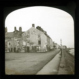
Home > Europe > United Kingdom > England > Cheshire > Newtown
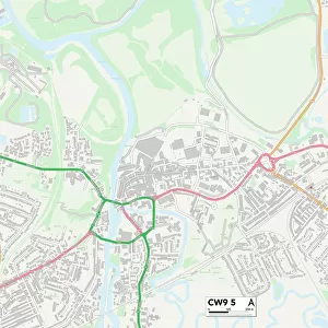
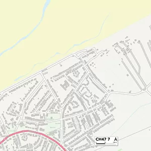
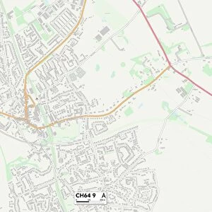
Cheshire West and Chester CH64 9 Map

![]()
Wall Art and Photo Gifts from Map Marketing
Cheshire West and Chester CH64 9 Map
Postcode Sector Map of Cheshire West and Chester CH64 9
Media ID 19967808
Ashtree Close Avon Close Bridge Court Bridge Street Brook Street Burton Road Cedar Grove Ch64 Cheshire West And Chester Chester Road Church Lane Cottage Close Derwent Way Drake Road Flag Lane Flint Close Frobisher Road Gladstone Road Grasmere Road Grenville Road Hawkins Road Henley Close High Street Highfield Close Highfield Road Ladies Walk Landseer Avenue Lees Lane Marlowe Road Meadow Close Morland Avenue Newtown Olive Road Orchard Walk Raby Road Raeburn Avenue Raleigh Road Roman Court Romney Close Romney Way Rydal Close Shakespeare Road Sidney Road Spenser Road Station Close Station Road Sutton Avenue Talbot Avenue Talbot Close Tannery Lane The Meadows Thirlmere Road Windermere Close Yewtree Close Neston Talbot Gardens
FEATURES IN THESE COLLECTIONS
> Arts
> Artists
> B
> John Brooks
> Arts
> Artists
> R
> Roman Roman
> Arts
> Artists
> S
> John Steeple
> Europe
> United Kingdom
> England
> Avon
> Europe
> United Kingdom
> England
> Cheshire
> Burton
> Europe
> United Kingdom
> England
> Cheshire
> Chester
> Europe
> United Kingdom
> England
> Cheshire
> Croft
> Europe
> United Kingdom
> England
> Cheshire
> Neston
> Europe
> United Kingdom
> England
> Cheshire
> Newtown
> Europe
> United Kingdom
> England
> Cheshire
> Related Images
> Map Marketing
> Postcode Sector Maps
> CH - Chester
MADE IN THE USA
Safe Shipping with 30 Day Money Back Guarantee
FREE PERSONALISATION*
We are proud to offer a range of customisation features including Personalised Captions, Color Filters and Picture Zoom Tools
SECURE PAYMENTS
We happily accept a wide range of payment options so you can pay for the things you need in the way that is most convenient for you
* Options may vary by product and licensing agreement. Zoomed Pictures can be adjusted in the Cart.