Home > Europe > United Kingdom > Wales > Conwy > Conwy
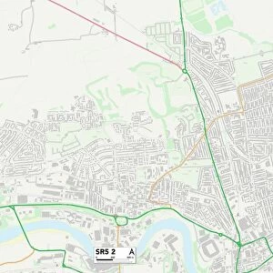
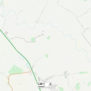
Liverpool L6 5 Map

![]()
Wall Art and Photo Gifts from Map Marketing
Liverpool L6 5 Map
Postcode Sector Map of Liverpool L6 5
Media ID 19973729
Amethyst Close Apollo Way Avon Street Barnes Street Belmont Grove Belmont Road Boundary Lane Lincoln Close Liverpool Mayfair Close Montgomery Way Norwood Grove Opal Close Pickering Street Reynolds Close Richmond Terrace Robin Way St Albans Thomson Street Thornwood Close Whitefield Road Woodville Terrace
FEATURES IN THESE COLLECTIONS
> Europe
> United Kingdom
> England
> Avon
> Europe
> United Kingdom
> Wales
> Ceredigion
> Cardigan
> Europe
> United Kingdom
> Wales
> Conwy
> Conwy
> Europe
> United Kingdom
> Wales
> Gwent
> Related Images
> Europe
> United Kingdom
> Wales
> Gwynedd
> Conwy
> Europe
> United Kingdom
> Wales
> Powys
> Montgomery
> Map Marketing
> Postcode Sector Maps
> L - Liverpool
> Maps and Charts
> Related Images
MADE IN THE USA
Safe Shipping with 30 Day Money Back Guarantee
FREE PERSONALISATION*
We are proud to offer a range of customisation features including Personalised Captions, Color Filters and Picture Zoom Tools
SECURE PAYMENTS
We happily accept a wide range of payment options so you can pay for the things you need in the way that is most convenient for you
* Options may vary by product and licensing agreement. Zoomed Pictures can be adjusted in the Cart.