Home > Europe > United Kingdom > Scotland > Fife > Buckhaven
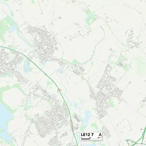
Leicester LE4 7 Map

![]()
Wall Art and Photo Gifts from Map Marketing
Leicester LE4 7 Map
Postcode Sector Map of Leicester LE4 7
Media ID 19973573
Alderton Close Archer Close Arran Road Badminton Road Barnes Close Bath Street Braemar Close Braemar Drive Butler Close Cameron Avenue Claremont Street Clarke Street Cotton Close Dalkeith Road Fieldhouse Road Gilbert Close Gleneagles Avenue Glenmore Road Kendal Road Leicester Lyle Close Marsh Close Melton Avenue Melton Road Oakland Avenue Rosedale Avenue Roseway Rushey Close Sandfield Close Sandringham Avenue Selkirk Road St Michaels Avenue Stafford Street Strathaven Road Strathmore Avenue Townsend Close Uxbridge Road Wetherby Road Woodbridge Road
FEATURES IN THESE COLLECTIONS
> Europe
> United Kingdom
> England
> Lancashire
> Related Images
> Europe
> United Kingdom
> England
> Lancashire
> Street
> Europe
> United Kingdom
> Scotland
> Aberdeenshire
> Stonehaven
> Europe
> United Kingdom
> Scotland
> Dumfries and Galloway
> Lockerbie
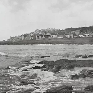
> Europe
> United Kingdom
> Scotland
> Fife
> Buckhaven
> Europe
> United Kingdom
> Scotland
> Highlands
> Cromarty
> Europe
> United Kingdom
> Scotland
> Lothian
> Dalkeith
> Europe
> United Kingdom
> Scotland
> Scottish Borders
> Peebles
> Europe
> United Kingdom
> Scotland
> Scottish Borders
> Selkirk
> Europe
> United Kingdom
> Scotland
> Stirlingshire
> Dunblane
> Map Marketing
> Postcode Sector Maps
> LE - Leicester
MADE IN THE USA
Safe Shipping with 30 Day Money Back Guarantee
FREE PERSONALISATION*
We are proud to offer a range of customisation features including Personalised Captions, Color Filters and Picture Zoom Tools
SECURE PAYMENTS
We happily accept a wide range of payment options so you can pay for the things you need in the way that is most convenient for you
* Options may vary by product and licensing agreement. Zoomed Pictures can be adjusted in the Cart.